IMAGES TAKEN NEAR TO
Hinksey Hill, OXFORD, OX1 5BD
Introduction
This page details the photographs taken nearby to Hinksey Hill, OX1 5BD by members of the Geograph project.
The Geograph project started in 2005 with the aim of publishing, organising and preserving representative images for every square kilometre of Great Britain, Ireland and the Isle of Man.

There are currently over 7.5m images from over14,400 individuals and you can help contribute to the project by visiting https://www.geograph.org.uk
Image Map
Images are licensed for reuse under creativecommons.org/licenses/by-sa/2.0
Notes
- Clicking on the map will re-center to the selected point.
- The higher the marker number, the further away the image location is from the centre of the postcode.
Image Listing (15 Images Found)
Images are licensed for reuse under creativecommons.org/licenses/by-sa/2.0
Image
Details
Distance
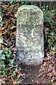
2
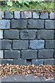
Benchmark on wall by 'The Firs', Hinksey Hill
Ordnance Survey cut mark benchmark described on the Bench Mark Database at http://www.bench-marks.org.uk/bm39758
Image: © Roger Templeman
Taken: 11 Oct 2011
0.10 miles
3
Entrance to 'The Firs', Hinksey Hill
The wall to the left of the entrance has an OS benchmark Image
Image: © Roger Templeman
Taken: 11 Oct 2011
0.10 miles
4
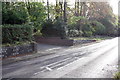
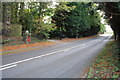
Badger Lane
Badger Lane nearing the junction with Hinksey Hill
Image: © Shaun Ferguson
Taken: 12 Mar 2010
0.14 miles
5
Entrance to Hadleigh House, Hinksey Hill
The gatepost with the stone ball on top is inscribed 'Woodside' and has a Edward VII postbox set into it. There is a similar gatepost at the other side of the entrance but is cloaked in ivy and not very obvious.
Image: © Roger Templeman
Taken: 11 Oct 2011
0.19 miles
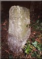
6
Milestone on Hinksey Hill with benchmark at bottom
Ordnance Survey cut mark benchmark described on the Bench Mark Database at http://www.bench-marks.org.uk/bm39757
Image: © Roger Templeman
Taken: 11 Oct 2011
0.21 miles
7
Old Milestone by the A4183, Hinksey Hill
Carved stone post by the A4183, in parish of South Hinksey (Vale of White Horse District), Hinksey Hill; next to Magpies, on ivy bank below bushes, on West side of road. Abingdon tombstone, erected by the Hinksey Road turnpike trust in the 19th century.
Inscription reads:-
OXFORD
2
ABINGDON
4
MILES
Oxfordshire HER.
HER Number: 10053 https://www.heritagegateway.org.uk/Gateway/Results_Single.aspx?uid=MOX10919&resourceID=1033
Milestone Society National ID: BE_OXAB02
Image: © A Rosevear
Taken: 8 Sep 2001
0.21 miles
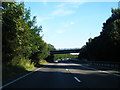
8
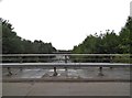
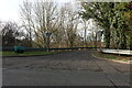
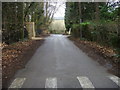
Oxford Ring Road crossing the A34
The ring road is not completely continuous but has a few points like this which either connect with adjoining roads and need to turn off or go above them altogether and have to cut back to continue on it.
Image: © David Howard
Taken: 28 Jul 2018
0.22 miles
9
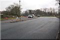
Roadworks on Southern By-Pass roundabout at Hinksey Hill
Image: © Roger Templeman
Taken: 27 Mar 2013
0.22 miles
10
A34 passes under Hinksey Hill Interchange
Image: © Colin Pyle
Taken: 10 Aug 2012
0.23 miles