IMAGES TAKEN NEAR TO
St. Lawrence Road, OXFORD, OX1 5AZ
Introduction
This page details the photographs taken nearby to St. Lawrence Road, OX1 5AZ by members of the Geograph project.
The Geograph project started in 2005 with the aim of publishing, organising and preserving representative images for every square kilometre of Great Britain, Ireland and the Isle of Man.

There are currently over 7.5m images from over14,400 individuals and you can help contribute to the project by visiting https://www.geograph.org.uk
Image Map
Images are licensed for reuse under creativecommons.org/licenses/by-sa/2.0
Notes
- Clicking on the map will re-center to the selected point.
- The higher the marker number, the further away the image location is from the centre of the postcode.
Image Listing (96 Images Found)
Images are licensed for reuse under creativecommons.org/licenses/by-sa/2.0
Image
Details
Distance
1
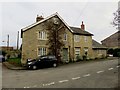
Cross Keys House on Manor Road
The Cross Keys is a former public house.
Image: © Steve Daniels
Taken: 21 Nov 2017
0.03 miles
2
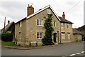
Cross Keys House on Manor Road
The house used to be the Cross Keys pub.
Image: © Steve Daniels
Taken: 17 Aug 2013
0.03 miles
3
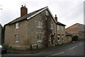
Cross Keys House at Manor Road / St Lawrence Road junction
There is an OS benchmark Image on the near corner, left hand face, of the former public house
Image: © Roger Templeman
Taken: 18 Jan 2016
0.03 miles
4
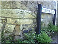
Benchmark on Cross Keys House, Manor Road
Ordnance Survey cut mark benchmark described on the Bench Mark Database at http://www.bench-marks.org.uk/bm23089.
Image: © Roger Templeman
Taken: 2 Sep 2010
0.03 miles
5
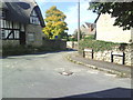
Junction of Manor Road and St Lawrence Road
Image: © Roger Templeman
Taken: 2 Sep 2010
0.03 miles
6
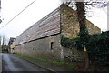
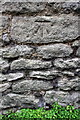
Barn conversion beside Manor Road
There is an OS benchmark Image on the building wall about 6m from the near end
Image: © Roger Templeman
Taken: 18 Jan 2016
0.04 miles
8
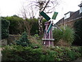
Windmill in Old South Hinksey
Feature in a garden of a private house.
Image: © Ian Paterson
Taken: 29 Jan 2008
0.04 miles
9
Benchmark on barn conversion on Manor Road
Ordnance Survey cut mark benchmark described on the Bench Mark Database at http://www.bench-marks.org.uk/bm72753
Image: © Roger Templeman
Taken: 18 Jan 2016
0.04 miles
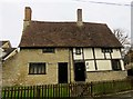
10
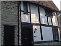
Bishops Cottage, South Hinksey
Afternoon sun (2:30 pm) emphasises the irregular timbered facade of this cottage on a corner of Manor Road in a little village not quite overwhelmed by the A34 Oxford bypass, no more than 200 metres from the camera. View looking SSE.
Image: © Derek Harper
Taken: 26 Nov 2005
0.04 miles