IMAGES TAKEN NEAR TO
Chilswell Path, OXFORD, OX1 5AP
Introduction
This page details the photographs taken nearby to Chilswell Path, OX1 5AP by members of the Geograph project.
The Geograph project started in 2005 with the aim of publishing, organising and preserving representative images for every square kilometre of Great Britain, Ireland and the Isle of Man.

There are currently over 7.5m images from over14,400 individuals and you can help contribute to the project by visiting https://www.geograph.org.uk
Image Map
Images are licensed for reuse under creativecommons.org/licenses/by-sa/2.0
Notes
- Clicking on the map will re-center to the selected point.
- The higher the marker number, the further away the image location is from the centre of the postcode.
Image Listing (81 Images Found)
Images are licensed for reuse under creativecommons.org/licenses/by-sa/2.0
Image
Details
Distance
7
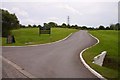
Entrance to Hinksey Heights Golf Course
Image: © Steve Daniels
Taken: 22 Jul 2009
0.12 miles
8
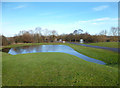
Little Pond near the Golf Course
By the entrance to Hinksey Golf Club, this isn't part of the course although it looks like it might be.
Image: © Des Blenkinsopp
Taken: 14 Jan 2014
0.13 miles
9
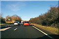
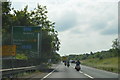
A34 northbound
Slow going around Oxford. This square was crossed at an average speed of 40 km/h (25 mph).
Image: © Robin Webster
Taken: 28 Dec 2017
0.14 miles
10
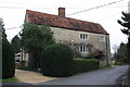
#7 Manor Road, "Stone Croft"
There is an OS benchmark Image on the near corner, left hand face, of the house
Image: © Roger Templeman
Taken: 18 Jan 2016
0.14 miles