IMAGES TAKEN NEAR TO
Foxcombe Drive, OXFORD, OX1 5AF
Introduction
This page details the photographs taken nearby to Foxcombe Drive, OX1 5AF by members of the Geograph project.
The Geograph project started in 2005 with the aim of publishing, organising and preserving representative images for every square kilometre of Great Britain, Ireland and the Isle of Man.

There are currently over 7.5m images from over14,400 individuals and you can help contribute to the project by visiting https://www.geograph.org.uk
Image Map (Loading...)


Getting Data...Please wait
Leaflet Map data © OpenStreetMap
Images are licensed for reuse under creativecommons.org/licenses/by-sa/2.0
Notes
- Clicking on the map will re-center to the selected point.
- The higher the marker number, the further away the image location is from the centre of the postcode.
Image Listing (12 Images Found)
Images are licensed for reuse under creativecommons.org/licenses/by-sa/2.0
Image
Details
Distance
1
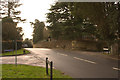
Junction of Fox Lane and Lincombe Lane
South lodge, partially obscured by trees. Footpath to Sunningwell on the left. The Fox Image is just down the hill to the South West.
Image: © Chris Drew
Taken: 7 Jan 2007
0.03 miles
2
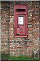
Benchmark and letter box, Foxcombe Lane
The wall is the boundary wall of Overdale Lodge at the junction of Foxcombe Road and Lincombe Lane. The Ordnance Survey cut mark benchmark is described on the Bench Mark Database at http://www.bench-marks.org.uk/bm27417
Image: © Roger Templeman
Taken: 22 Mar 2013
0.04 miles
3
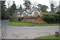
Overdale Lodge at Foxcombe Road / Lincombe Lane junction
There is an OS benchmark Image on the wall pier beneath the George VI letterbox
Image: © Roger Templeman
Taken: 22 Mar 2013
0.04 miles
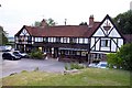
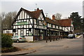
6
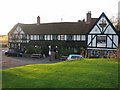
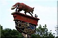
The Fox
The Fox, a popular pub and restaurant on Fox Combe Road just south of Boars Hill.
Image: © Anne Pollitt
Taken: 2 Dec 2006
0.16 miles
8
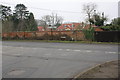
Benchmark on roadside farm building wall, Foxcombe Road
Ordnance Survey cut mark benchmark described on the Bench Mark Database at http://www.bench-marks.org.uk/bm47749
Image: © Roger Templeman
Taken: 22 Mar 2013
0.22 miles
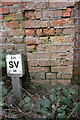
9
Junction of Berkeley Road and Foxcombe Road
There is an OS benchmark Image on the wall pier right of the SV sign, itself right of the road name sign. The wall is in fact one boundary wall of a farm 3-sided roofless enclosure.
Image: © Roger Templeman
Taken: 22 Mar 2013
0.22 miles
10
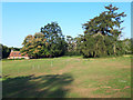
Public footpath on Foxcombe Hill
A public footpath (right of way number 6 in Sunningwell parish) crosses this field east-west. Normally parts of the field are fenced off for horses and ponies to graze, although on this occasion the electric fence is absent and the animals are roaming freely (out of sight in this photograph). On the far side of this field the path ends at the kissing gate which leads through to Lincombe Lane. There is a particularly large larch tree in this field, seen on the right in this photograph.
Image: © Jim Champion
Taken: 8 Aug 2020
0.23 miles