IMAGES TAKEN NEAR TO
Apollo Office Park Ironstone Lane, BANBURY, OX15 6FE
Introduction
This page details the photographs taken nearby to Apollo Office Park Ironstone Lane, OX15 6FE by members of the Geograph project.
The Geograph project started in 2005 with the aim of publishing, organising and preserving representative images for every square kilometre of Great Britain, Ireland and the Isle of Man.

There are currently over 7.5m images from over14,400 individuals and you can help contribute to the project by visiting https://www.geograph.org.uk
Image Map (Loading...)


Getting Data...Please wait
Leaflet Map data © OpenStreetMap
Images are licensed for reuse under creativecommons.org/licenses/by-sa/2.0
Notes
- Clicking on the map will re-center to the selected point.
- The higher the marker number, the further away the image location is from the centre of the postcode.
Image Listing (9 Images Found)
Images are licensed for reuse under creativecommons.org/licenses/by-sa/2.0
Image
Details
Distance
1

The W O Bentley Memorial Building
This building is the headquarters of the Bentley Drivers Club, and contains the archives relating to the great motor engineer W O Bentley and the cars that will always be associated with him. The site was formerly the location of the headquarters of the Oxfordshire Ironstone Company.
The cars on display outside are Rileys.
Image: © Richard Green
Taken: 14 May 2013
0.05 miles
2

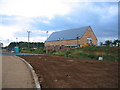
Developments at Oxfordshire Ironstone Quarries Headquarters site
This used to be the Image and was the processing point for the ironstone and hub of the extensive quarry railway network. The quarries closed in September 1967 however the buildings on this site continued to be used for a variety of purposes. As can be seen from the picture, the site is currently being extensively redeveloped as a business park. See http://www.apolloofficepark.co.uk/history.htm
Image: © David Stowell
Taken: 7 Jul 2006
0.08 miles
3
Oxfordshire Ironstone Quarries Headquarters site
This site is the former headquarters of the extensive Oxfordshire Ironstone Quarries. Quarrying commenced in January 1919 and the output was carried by the quarry's own railway to the Great Western Main line at SP463429 just north of Banbury. Much of the course of this railway can still be traced today (such as Image and Image) as it is variously a footpath, cycle way and nature reserve.
The extensive quarry network extended to the NW eventually reaching Alkerton under Image and Image It also ran to the SW through Image and Image
The quarries eventually closed in September 1967 however the buildings on this site continued to be used for a variety of purposes and are now the Apollo Image
Historical detail courtesy of "The Ironstone Quarries of the Midlands - Part II The Oxfordshire Field" by Eric Tonks, published by Moor Graphics, April 1988. ISBN 1-870754-02-6
Image: © David Stowell
Taken: 7 Jul 2006
0.08 miles
4

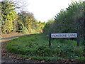
Ironstone Lane
Indicative of the local Geology. Iron gives the colouring to the local Hornton stone. This lane with its new fence leads south off the minor road from Hornton to Wroxton.
Image: © Nigel Mykura
Taken: 11 Mar 2018
0.10 miles
5
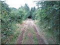
Course of Oxfordshire Ironstone Quarry Railway
Part of the alignment of the former quarry railway network radiating from the Image at Wroxton.
Image: © David Stowell
Taken: 7 Jul 2006
0.10 miles
6

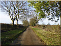
Lane towards Hornton
It might be called Drift Lane, as it is east of the junction with Ironstone Lane.
Image: © Robin Webster
Taken: 13 Nov 2016
0.10 miles

8
Drift Lane from end of Ironstone Lane
Drift Lane goes towards Wroxton.
Image: © Robin Webster
Taken: 13 Nov 2016
0.13 miles
9
Lane towards Hornton from Wroxton
It might be called Drift Lane, as it is east of the junction with Ironstone Lane.
Image: © Robin Webster
Taken: 13 Nov 2016
0.18 miles