IMAGES TAKEN NEAR TO
Balscote, BANBURY, OX15 6EX
Introduction
This page details the photographs taken nearby to OX15 6EX by members of the Geograph project.
The Geograph project started in 2005 with the aim of publishing, organising and preserving representative images for every square kilometre of Great Britain, Ireland and the Isle of Man.

There are currently over 7.5m images from over14,400 individuals and you can help contribute to the project by visiting https://www.geograph.org.uk
Image Map
Images are licensed for reuse under creativecommons.org/licenses/by-sa/2.0
Notes
- Clicking on the map will re-center to the selected point.
- The higher the marker number, the further away the image location is from the centre of the postcode.
Image Listing (3 Images Found)
Images are licensed for reuse under creativecommons.org/licenses/by-sa/2.0
Image
Details
Distance
1
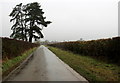
Road From Balscote to Shutford
A dull dreary and very rainy day on this minor road. This is looking south towards Shutford.
Image: © Nigel Mykura
Taken: 11 Mar 2018
0.12 miles
2
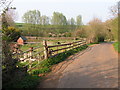
Allotments at Plot Road, Lower End, Shutford
Shutford has a number of allotments available for rent. These are located at the northern end of Shutford.
Image: © G Olsson
Taken: 15 Apr 2007
0.16 miles
3
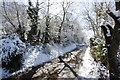
Winter view along Back Lane Shutford
Looking towards Shutford along Back Lane. Taken 6th April 2008
Image: © Chris Beach
Taken: 6 Apr 2008
0.19 miles