IMAGES TAKEN NEAR TO
Sibford Gower, BANBURY, OX15 5RY
Introduction
This page details the photographs taken nearby to OX15 5RY by members of the Geograph project.
The Geograph project started in 2005 with the aim of publishing, organising and preserving representative images for every square kilometre of Great Britain, Ireland and the Isle of Man.

There are currently over 7.5m images from over14,400 individuals and you can help contribute to the project by visiting https://www.geograph.org.uk
Image Map (Loading...)


Getting Data...Please wait
Leaflet Map data © OpenStreetMap
Images are licensed for reuse under creativecommons.org/licenses/by-sa/2.0
Notes
- Clicking on the map will re-center to the selected point.
- The higher the marker number, the further away the image location is from the centre of the postcode.
Image Listing (8 Images Found)
Images are licensed for reuse under creativecommons.org/licenses/by-sa/2.0
Image
Details
Distance
1
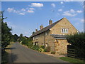
The Colony
The Colony consists of several rows of cottages beside the road approaching Sibford Gower from the south west.
Image: © David Stowell
Taken: 19 Jul 2006
0.02 miles
2
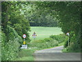
Approach to Sibford Gower and Burdrop
Image: © Sarah Charlesworth
Taken: 23 May 2011
0.04 miles
3

Enocks Colony Sibford Gower
A series of cottages presumably for agricultural labourers, called Enocks Colony in the 1881 Census. Now show on OS maps as just The Colony.
Image: © Andrew Davis
Taken: 19 Sep 2008
0.10 miles
4
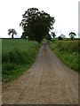
Bridleway and track
Bridleway and track to Haynes's Barn near Sibford Gower.
Image: © Philip Halling
Taken: 5 Jun 2019
0.15 miles
5
![Towards Sibford Gower [5]](https://s1.geograph.org.uk/geophotos/02/73/05/2730577_d96db252_120x120.jpg)
Towards Sibford Gower [5]
In the bottom of the valley the stream (one of the many streams that make up the infant River Stour) is crossed on this footbridge.
Image: © Michael Dibb
Taken: 28 Aug 2011
0.21 miles
6
![Towards Sibford Gower [6]](https://s0.geograph.org.uk/geophotos/02/73/05/2730580_f452d1ed_120x120.jpg)
Towards Sibford Gower [6]
Just beyond the stream, a rather complicated arrangement of steps and stile is required to pass into the next field
Image: © Michael Dibb
Taken: 28 Aug 2011
0.21 miles
7
![Towards Sibford Gower [4]](https://s1.geograph.org.uk/geophotos/02/73/05/2730573_b0fade30_120x120.jpg)
Towards Sibford Gower [4]
The path continues to descend towards the valley bottom to cross the stream before starting the ascent to Sibford Gower.
Image: © Michael Dibb
Taken: 28 Aug 2011
0.21 miles
8
![Towards Sibford Gower [3]](https://s0.geograph.org.uk/geophotos/02/73/05/2730572_adc0c5d8_120x120.jpg)
Towards Sibford Gower [3]
The path runs straight across this field on its way to the valley bottom to cross the stream.
Image: © Michael Dibb
Taken: 28 Aug 2011
0.23 miles