IMAGES TAKEN NEAR TO
Hook Norton, BANBURY, OX15 5LU
Introduction
This page details the photographs taken nearby to OX15 5LU by members of the Geograph project.
The Geograph project started in 2005 with the aim of publishing, organising and preserving representative images for every square kilometre of Great Britain, Ireland and the Isle of Man.

There are currently over 7.5m images from over14,400 individuals and you can help contribute to the project by visiting https://www.geograph.org.uk
Image Map (Loading...)


Getting Data...Please wait
Leaflet Map data © OpenStreetMap
Images are licensed for reuse under creativecommons.org/licenses/by-sa/2.0
Notes
- Clicking on the map will re-center to the selected point.
- The higher the marker number, the further away the image location is from the centre of the postcode.
Image Listing (46 Images Found)
Images are licensed for reuse under creativecommons.org/licenses/by-sa/2.0
Image
Details
Distance
1
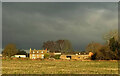
Manor Farm
The listed farmhouse is described at https://historicengland.org.uk/listing/the-list/list-entry/1369835?section=official-listing .
Image: © Derek Harper
Taken: 9 Feb 2022
0.00 miles
2
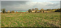
Manor Farm
A distant view from footpath 253 24/10. See Image] for a more detailed view.
Image: © Derek Harper
Taken: 9 Feb 2022
0.03 miles
3
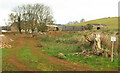
Manor Farm
A stern warning on footpath 253 22/20: "nobody beyond this point" is in red. The path veers left here, further left than the map indicates, in order to get around the renovation work on the farm's outbuildings. The listed farmhouse behind the trees is described at https://historicengland.org.uk/listing/the-list/list-entry/1369835?section=official-listing .
Image: © Derek Harper
Taken: 9 Feb 2022
0.03 miles
4
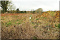
Waymark, Manor Farm
A much sought-after waymark on the redirected footpath 253 22/20 around Manor Farm.
Image: © Derek Harper
Taken: 9 Feb 2022
0.07 miles
5
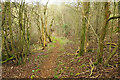
Footpath near Manor Farm
Footpath 253 22/20 dropping through woodland to the Hook Norton Brook valley.
Image: © Derek Harper
Taken: 9 Feb 2022
0.07 miles
6
Manor Farm
As seen from a passing footpath. Butter Hill is to the right.
Image: © Bill Boaden
Taken: 27 Jan 2022
0.07 miles
7
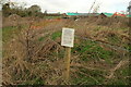
Notice, Manor Farm
A reassuring notice on the redirected footpath 253 22/20; see also Image] and Image Unfortunately the map it refers to is missing. Farm buildings undergoing renovation can be seen in the background.
Image: © Derek Harper
Taken: 9 Feb 2022
0.08 miles
8
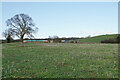
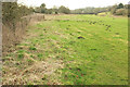
Field by Manor Farm
From the footbridge where Image] was taken, with Manor Farm right of centre.
Image: © Derek Harper
Taken: 9 Feb 2022
0.08 miles
9
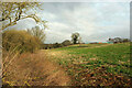
In the Hook Norton Brook valley
Looking in the other direction from Image
Image: © Derek Harper
Taken: 9 Feb 2022
0.09 miles
10
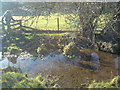
Reflections in the stream, near Manor Farm
Image: © Dave Favis-Mortlock
Taken: 14 Jan 2012
0.10 miles