IMAGES TAKEN NEAR TO
Station Road, BANBURY, OX15 5LT
Introduction
This page details the photographs taken nearby to Station Road, OX15 5LT by members of the Geograph project.
The Geograph project started in 2005 with the aim of publishing, organising and preserving representative images for every square kilometre of Great Britain, Ireland and the Isle of Man.

There are currently over 7.5m images from over14,400 individuals and you can help contribute to the project by visiting https://www.geograph.org.uk
Image Map (Loading...)


Getting Data...Please wait
Leaflet Map data © OpenStreetMap
Images are licensed for reuse under creativecommons.org/licenses/by-sa/2.0
Notes
- Clicking on the map will re-center to the selected point.
- The higher the marker number, the further away the image location is from the centre of the postcode.
Image Listing (6 Images Found)
Images are licensed for reuse under creativecommons.org/licenses/by-sa/2.0
Image
Details
Distance
2
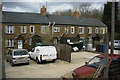
Brymbo Cottages
Cottages built by the Brymbo Steel Company for their key workers, early 20th century.
Image: © Gareth Richard
Taken: 17 Apr 2006
0.09 miles
3
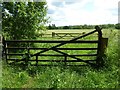
Double gates
Double gates into a field to the east of Hook Norton.
Image: © Philip Halling
Taken: 7 Jun 2017
0.16 miles
4
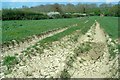
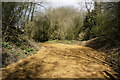
Cracking weather!
It is surprising how quickly the ground has dried out after all the rain during the winter.
Farm track leading to a bridge over the disused railway line.
Image: © David Luther Thomas
Taken: 20 Apr 2007
0.18 miles
5
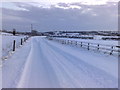
Remains of Black Bridge
Black Bridge allowed the Banbury to Cheltenham Railway to cross a farm track, and later a mineral line from Redland Quarry to the Furnaces. The abutments were crushed to make the roadway.
Image: © Gareth Richard
Taken: 17 Apr 2006
0.18 miles
6

Footpath to Hook Norton
Footpath 253 22/20 moves away from the stile shown in Image
Image: © Derek Harper
Taken: 9 Feb 2022
0.25 miles