IMAGES TAKEN NEAR TO
Down End, BANBURY, OX15 5LL
Introduction
This page details the photographs taken nearby to Down End, OX15 5LL by members of the Geograph project.
The Geograph project started in 2005 with the aim of publishing, organising and preserving representative images for every square kilometre of Great Britain, Ireland and the Isle of Man.

There are currently over 7.5m images from over14,400 individuals and you can help contribute to the project by visiting https://www.geograph.org.uk
Image Map (Loading...)


Getting Data...Please wait
Leaflet Map data © OpenStreetMap
Images are licensed for reuse under creativecommons.org/licenses/by-sa/2.0
Notes
- Clicking on the map will re-center to the selected point.
- The higher the marker number, the further away the image location is from the centre of the postcode.
Image Listing (187 Images Found)
Images are licensed for reuse under creativecommons.org/licenses/by-sa/2.0
Image
Details
Distance
1
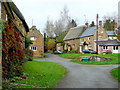
Hook Norton cottages 2
Down End looking towards the village centre.
Image: © Jonathan Billinger
Taken: 26 Nov 2011
0.01 miles
2
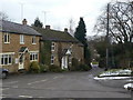
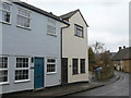
Down End
The lane shares its name with the area of the village through which it passes.
Image: © Alan Murray-Rust
Taken: 22 Feb 2010
0.02 miles
3
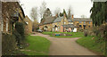
Down End, Hook Norton
A junction with grass triangle towards the east end of the village. The thatched cottage left of centre is The Old Malt House Cottage https://historicengland.org.uk/listing/the-list/list-entry/1046286?section=official-list-entry .
Image: © Derek Harper
Taken: 9 Feb 2022
0.03 miles
4
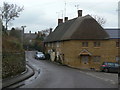
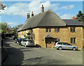
Corner Cottage
On the corner of High Street and Down End. An attractive group of cottages in the local ironstone with thatched roofs.
Image: © Alan Murray-Rust
Taken: 22 Feb 2010
0.04 miles
5
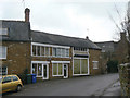
Lion House Dental Practice
Occupying premises that were clearly formerly a shop.
Image: © Alan Murray-Rust
Taken: 22 Feb 2010
0.04 miles
6
Corner Cottage
Grade II listed as English Heritage Building ID: 244020 and called Cornerways, Hook Norton. The cottage dates from the 17th C.
Image: © Stuart Logan
Taken: 13 Apr 2014
0.04 miles
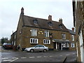
7
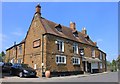
The Bell Inn
Feelings amongst the residents of Hook Norton are running high amidst palns to convert The Bell pub into an estate agents. http://www.banburyguardian.co.uk/news/localvillagers-fury-at-plan-to-transform-bell-inn-1-4771377
Update: September 2015
The Bell Inn has been converted to a residential dwelling.
Image: © Helen Iwanczuk
Taken: 6 Jul 2013
0.04 miles
8
The Old Co-op
This is the name of the right hand of this pair of houses. Presumably it was once a Co-op store, but there is no obvious sign of this now.
Image: © Alan Murray-Rust
Taken: 22 Feb 2010
0.04 miles
9
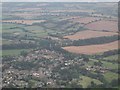
Hook Norton
The village as seen from a hot air balloon. The pillars in the distance carried a viaduct for the Cheltenham and Banbury Railway.
Image: © David Stowell
Taken: 20 Aug 2002
0.06 miles
10
THE EL N
The hanging sign gives a clue to the missing letters - this is the Bell Inn, probably built in the 17t/18th centuries as a dwelling house, but at some stage converted into a pub. Listed Grade II.
Image: © Alan Murray-Rust
Taken: 22 Feb 2010
0.06 miles