IMAGES TAKEN NEAR TO
Bells Lane, BANBURY, OX15 5LJ
Introduction
This page details the photographs taken nearby to Bells Lane, OX15 5LJ by members of the Geograph project.
The Geograph project started in 2005 with the aim of publishing, organising and preserving representative images for every square kilometre of Great Britain, Ireland and the Isle of Man.

There are currently over 7.5m images from over14,400 individuals and you can help contribute to the project by visiting https://www.geograph.org.uk
Image Map (Loading...)


Getting Data...Please wait
Leaflet Map data © OpenStreetMap
Images are licensed for reuse under creativecommons.org/licenses/by-sa/2.0
Notes
- Clicking on the map will re-center to the selected point.
- The higher the marker number, the further away the image location is from the centre of the postcode.
Image Listing (172 Images Found)
Images are licensed for reuse under creativecommons.org/licenses/by-sa/2.0
Image
Details
Distance
1
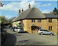
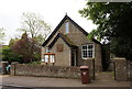
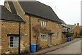
Corner Cottage
Grade II listed as English Heritage Building ID: 244020 and called Cornerways, Hook Norton. The cottage dates from the 17th C.
Image: © Stuart Logan
Taken: 13 Apr 2014
0.02 miles
2
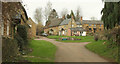
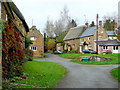
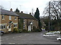
Down End, Hook Norton
A junction with grass triangle towards the east end of the village. The thatched cottage left of centre is The Old Malt House Cottage https://historicengland.org.uk/listing/the-list/list-entry/1046286?section=official-list-entry .
Image: © Derek Harper
Taken: 9 Feb 2022
0.04 miles
3
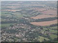
Hook Norton
The village as seen from a hot air balloon. The pillars in the distance carried a viaduct for the Cheltenham and Banbury Railway.
Image: © David Stowell
Taken: 20 Aug 2002
0.04 miles
6
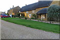
Hook Norton cottages 2
Down End looking towards the village centre.
Image: © Jonathan Billinger
Taken: 26 Nov 2011
0.05 miles
9
Down End
The lane shares its name with the area of the village through which it passes.
Image: © Alan Murray-Rust
Taken: 22 Feb 2010
0.06 miles
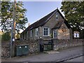
10
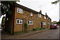
The Old Post Office, Hook Norton
Dated 1676, and described at https://historicengland.org.uk/listing/the-list/list-entry/1283828?section=official-list-entry . On Chapel Street, used by the D'Arcy Dalton Way.
Image: © Derek Harper
Taken: 10 Feb 2022
0.06 miles