IMAGES TAKEN NEAR TO
Sibford Road, BANBURY, OX15 5JX
Introduction
This page details the photographs taken nearby to Sibford Road, OX15 5JX by members of the Geograph project.
The Geograph project started in 2005 with the aim of publishing, organising and preserving representative images for every square kilometre of Great Britain, Ireland and the Isle of Man.

There are currently over 7.5m images from over14,400 individuals and you can help contribute to the project by visiting https://www.geograph.org.uk
Image Map (Loading...)


Getting Data...Please wait
Leaflet Map data © OpenStreetMap
Images are licensed for reuse under creativecommons.org/licenses/by-sa/2.0
Notes
- Clicking on the map will re-center to the selected point.
- The higher the marker number, the further away the image location is from the centre of the postcode.
Image Listing (80 Images Found)
Images are licensed for reuse under creativecommons.org/licenses/by-sa/2.0
Image
Details
Distance
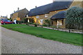
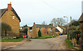
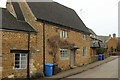
2
The Triangle, Hook Norton
The houses in the centre are on a triangular site surrounded by lanes. On the immediate right, Bell's Lane joins Chapel Street. The thatched cottage glimpsed right of centre is The Old Surgery, listed and described at https://historicengland.org.uk/listing/the-list/list-entry/1046289?section=official-list-entry .
Image: © Derek Harper
Taken: 10 Feb 2022
0.06 miles
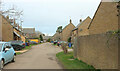
3
The Triangle, Hook Norton
The small green at the eastern corner of the triangular site seen in Image On the extreme right is a fragment of The Old Surgery, glimpsed in that image. On the left, but seen much more clearly at Image], is the listed Long Thatch https://historicengland.org.uk/listing/the-list/list-entry/1369868?section=official-list-entry .
Image: © Derek Harper
Taken: 10 Feb 2022
0.06 miles
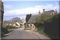
5

Long Thatch, Hook Norton
Living up to its name. Listed and described at https://historicengland.org.uk/listing/the-list/list-entry/1369868?section=official-list-entry . The gable end alone is shown in Image As the signpost in the foreground indicates, this is where the D'Arcy Dalton Way joins the road. The footpath is 253 35/10.
Image: © Derek Harper
Taken: 10 Feb 2022
0.07 miles
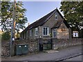
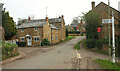
7
Hollybush Road, Hook Norton
A view from the D'Arcy Dalton Way, but it take a narrow path just to the right of the camera.
Image: © Derek Harper
Taken: 10 Feb 2022
0.08 miles
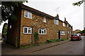
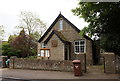
8
The Old Post Office, Hook Norton
Dated 1676, and described at https://historicengland.org.uk/listing/the-list/list-entry/1283828?section=official-list-entry . On Chapel Street, used by the D'Arcy Dalton Way.
Image: © Derek Harper
Taken: 10 Feb 2022
0.08 miles