IMAGES TAKEN NEAR TO
Swerford Road, BANBURY, OX15 5JR
Introduction
This page details the photographs taken nearby to Swerford Road, OX15 5JR by members of the Geograph project.
The Geograph project started in 2005 with the aim of publishing, organising and preserving representative images for every square kilometre of Great Britain, Ireland and the Isle of Man.

There are currently over 7.5m images from over14,400 individuals and you can help contribute to the project by visiting https://www.geograph.org.uk
Image Map (Loading...)


Getting Data...Please wait
Leaflet Map data © OpenStreetMap
Images are licensed for reuse under creativecommons.org/licenses/by-sa/2.0
Notes
- Clicking on the map will re-center to the selected point.
- The higher the marker number, the further away the image location is from the centre of the postcode.
Image Listing (14 Images Found)
Images are licensed for reuse under creativecommons.org/licenses/by-sa/2.0
Image
Details
Distance
1
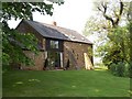
Oak House
This barn conversion commands some lovely views over Hook Norton.
Image: © Michael Dibb
Taken: 30 Apr 2011
0.00 miles
2
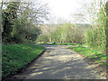
Un-named lane junction with Swerford Road
Image: © Stuart Logan
Taken: 13 Apr 2014
0.05 miles
3
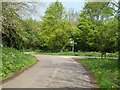
Country junction
The minor road descends towards its junction with Swerford Road.
Image: © Michael Dibb
Taken: 30 Apr 2011
0.06 miles
4
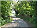
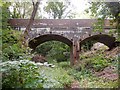
Over the railway
A view of the parapets of the bridge carrying Swerford Road over the dismantled Banbury & Cheltenham Direct Railway.
Image: © Michael Dibb
Taken: 30 Apr 2011
0.14 miles
5
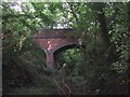
Hook Norton-Dismantled Railway
The Swerford Road bridge crosses the dismantled Banbury to Cheltenham railway line, which is now a Nature Reserve.
Image: © Ian Rob
Taken: 14 Aug 2018
0.14 miles
6
![Once were trains [1]](https://s2.geograph.org.uk/geophotos/02/43/21/2432166_b8916654_120x120.jpg)
Once were trains [1]
A view looking south of the trackbed of the dismantled Banbury & Cheltenham Direct Railway from the bridge carrying Swerford Road. The line opened in stages from 1855 to 1881 and finally closed to passengers in 1962. Part of the cutting is now a nature reserve.
Image: © Michael Dibb
Taken: 30 Apr 2011
0.14 miles
7
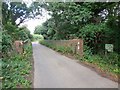
Swerford Road crosses the disused Banbury to Cheltenham railway line
Image: © Sarah Charlesworth
Taken: 25 Aug 2009
0.14 miles
8
Hook Norton-Dismantled Railway
The eastern end of the bridge over the dismantled Banbury to Cheltenham line.
Showing the entrance to the Nature Reserve.
Image: © Ian Rob
Taken: 14 Aug 2018
0.16 miles
9
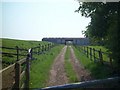
Track through the barn
The track runs up to and through the barn, seen from Swerford Road.
Image: © Michael Dibb
Taken: 30 Apr 2011
0.20 miles
10
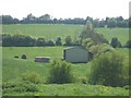
Modern field barn
This isolated barn is seen from the footpath.
Image: © Michael Dibb
Taken: 30 Apr 2011
0.21 miles