IMAGES TAKEN NEAR TO
Brailes, BANBURY, OX15 5JJ
Introduction
This page details the photographs taken nearby to OX15 5JJ by members of the Geograph project.
The Geograph project started in 2005 with the aim of publishing, organising and preserving representative images for every square kilometre of Great Britain, Ireland and the Isle of Man.

There are currently over 7.5m images from over14,400 individuals and you can help contribute to the project by visiting https://www.geograph.org.uk
Image Map (Loading...)


Getting Data...Please wait
Leaflet Map data © OpenStreetMap
Images are licensed for reuse under creativecommons.org/licenses/by-sa/2.0
Notes
- Clicking on the map will re-center to the selected point.
- The higher the marker number, the further away the image location is from the centre of the postcode.
Image Listing (3 Images Found)
Images are licensed for reuse under creativecommons.org/licenses/by-sa/2.0
Image
Details
Distance
1
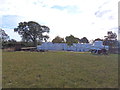
Well wrapped bales
These bales, stored near the road, are well wrapped. Seen from the footpath.
Image: © Michael Dibb
Taken: 29 Oct 2011
0.06 miles
2
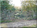
Over the stile
The footpath crosses the muddy track then passes over the stile on its way to Upper Brailes.
Image: © Michael Dibb
Taken: 29 Oct 2011
0.11 miles
3
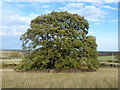
Oak tree
This magnificent oak tree stands alone near Lower Chelmscote Farm. Seen from the footpath.
Image: © Michael Dibb
Taken: 29 Oct 2011
0.20 miles