IMAGES TAKEN NEAR TO
Wigginton Heath, BANBURY, OX15 5HJ
Introduction
This page details the photographs taken nearby to OX15 5HJ by members of the Geograph project.
The Geograph project started in 2005 with the aim of publishing, organising and preserving representative images for every square kilometre of Great Britain, Ireland and the Isle of Man.

There are currently over 7.5m images from over14,400 individuals and you can help contribute to the project by visiting https://www.geograph.org.uk
Image Map (Loading...)


Getting Data...Please wait
Leaflet Map data © OpenStreetMap
Images are licensed for reuse under creativecommons.org/licenses/by-sa/2.0
Notes
- Clicking on the map will re-center to the selected point.
- The higher the marker number, the further away the image location is from the centre of the postcode.
Image Listing (5 Images Found)
Images are licensed for reuse under creativecommons.org/licenses/by-sa/2.0
Image
Details
Distance
1
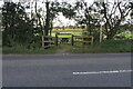
Road junction and grass triangle
By Wigginton Heath, the minor road to Swalcliffe Grange.
Image: © Michael Trolove
Taken: 19 Apr 2017
0.04 miles
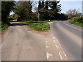
2
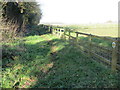
Start of a Bridleway that goes to Swalcliffe
Looking north-westward.
Image: © Peter Wood
Taken: 10 Nov 2017
0.07 miles
3

View to Brailes Hill
View to Brailes Hill with its distinctive clump of trees on its summit, viewed here across a wheat field from Wigginton Heath.
Image: © Philip Halling
Taken: 12 Jul 2012
0.14 miles
4
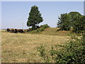
Cattle and Fort
The bump to the right of the cattle is the remains of an ancient fort. A road passes over the top of the fort as it probably did when it was active.
Image: © Michael Patterson
Taken: 12 Jul 2006
0.20 miles