IMAGES TAKEN NEAR TO
Traitors Ford Lane, BANBURY, OX15 5FE
Introduction
This page details the photographs taken nearby to Traitors Ford Lane, OX15 5FE by members of the Geograph project.
The Geograph project started in 2005 with the aim of publishing, organising and preserving representative images for every square kilometre of Great Britain, Ireland and the Isle of Man.

There are currently over 7.5m images from over14,400 individuals and you can help contribute to the project by visiting https://www.geograph.org.uk
Image Map (Loading...)


Getting Data...Please wait
Leaflet Map data © OpenStreetMap
Images are licensed for reuse under creativecommons.org/licenses/by-sa/2.0
Notes
- Clicking on the map will re-center to the selected point.
- The higher the marker number, the further away the image location is from the centre of the postcode.
Image Listing (10 Images Found)
Images are licensed for reuse under creativecommons.org/licenses/by-sa/2.0
Image
Details
Distance
1
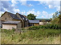
Lower Atchill Farm
Seen from the bridleway.
Image: © Michael Dibb
Taken: 28 Aug 2011
0.01 miles
2
Lower Atchill
Seen from the bridleway near Round Hill.
Image: © Michael Dibb
Taken: 29 Aug 2010
0.02 miles
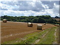
3
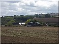
View towards Lower Atchill
The hedge line runs down to Lower Atchill (farm). The whole of this west side of this slope running down from the Ditchedge Lane ridge is given to arable farmland.
Image: © Graham Horn
Taken: 28 Apr 2007
0.10 miles
4
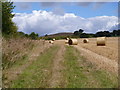
Towards Round Hill
The bridleway follows the field edge as it gently ascends. Round Hill is in the background.
Image: © Michael Dibb
Taken: 28 Aug 2011
0.12 miles
5
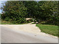
Driveway to Lower Atchill
From Traitor's Ford Lane is seen the tree-lined driveway to Lower Atchill Farm.
Image: © Michael Dibb
Taken: 28 Aug 2011
0.18 miles
6
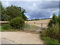
Start of bridleway
From Traitor's Ford Lane and alongside the driveway to Lower Atchill Farm, the bridleway runs to Round Hill then on to Lower Brailes.
Image: © Michael Dibb
Taken: 28 Aug 2011
0.19 miles
7
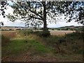
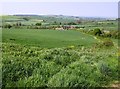
Towards Fisher's Barn
A view over the valley of the River Stour, seen from the bridleway.
Image: © Michael Dibb
Taken: 29 Aug 2010
0.22 miles
8
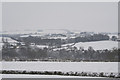
Looking south from College Barn Farm, Sibford Gower
A winter scene looking south across the open countryside from College Barn Farm, Sibford Gower. Leys Farm can be seen in the distance. Taken 8th February 2007.
Image: © Geoff Powell
Taken: 8 Feb 2007
0.22 miles
9
Coppice view
From the bridleway, A view down the field towards Traitor's Ford Lane and Traitor's Ford Coppice.
Image: © Michael Dibb
Taken: 28 Aug 2011
0.23 miles
10
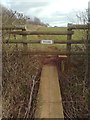
'No entry' path leading from Ditchedge Lane
Image: © Dave Favis-Mortlock
Taken: 7 Jan 2012
0.25 miles