IMAGES TAKEN NEAR TO
Wykham Lane, BANBURY, OX15 5DS
Introduction
This page details the photographs taken nearby to Wykham Lane, OX15 5DS by members of the Geograph project.
The Geograph project started in 2005 with the aim of publishing, organising and preserving representative images for every square kilometre of Great Britain, Ireland and the Isle of Man.

There are currently over 7.5m images from over14,400 individuals and you can help contribute to the project by visiting https://www.geograph.org.uk
Image Map (Loading...)


Getting Data...Please wait
Leaflet Map data © OpenStreetMap
Images are licensed for reuse under creativecommons.org/licenses/by-sa/2.0
Notes
- Clicking on the map will re-center to the selected point.
- The higher the marker number, the further away the image location is from the centre of the postcode.
Image Listing (5 Images Found)
Images are licensed for reuse under creativecommons.org/licenses/by-sa/2.0
Image
Details
Distance
1
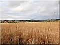
Fields north of Wykham Lane
Crops struggling to ripen in the patchy sunlight, after a very wet summer.
Image: © David P Howard
Taken: 2 Aug 2012
0.06 miles
2

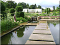
Broughton Grange
Mowing the paddock. A car parking area is to the right.
Image: © Robin Stott
Taken: 11 Jun 2009
0.06 miles
3
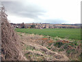
East of Broughton
Farmland on the Oxfordshire wolds at 137 metres.
Image: © Dennis Turner
Taken: 9 Apr 2006
0.11 miles
4
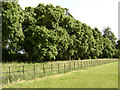
Broughton Grange
The avenue, said to be Cork Oak, down the original drive.
Image: © Robin Stott
Taken: 11 Jun 2009
0.14 miles