IMAGES TAKEN NEAR TO
Upper Brailes, BANBURY, OX15 5AX
Introduction
This page details the photographs taken nearby to OX15 5AX by members of the Geograph project.
The Geograph project started in 2005 with the aim of publishing, organising and preserving representative images for every square kilometre of Great Britain, Ireland and the Isle of Man.

There are currently over 7.5m images from over14,400 individuals and you can help contribute to the project by visiting https://www.geograph.org.uk
Image Map (Loading...)


Getting Data...Please wait
Leaflet Map data © OpenStreetMap
Images are licensed for reuse under creativecommons.org/licenses/by-sa/2.0
Notes
- Clicking on the map will re-center to the selected point.
- The higher the marker number, the further away the image location is from the centre of the postcode.
Image Listing (37 Images Found)
Images are licensed for reuse under creativecommons.org/licenses/by-sa/2.0
Image
Details
Distance
1
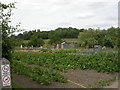
Upper Brailes, allotments
Off High Street, looking towards Castle Hill.
Image: © Mike Faherty
Taken: 2 Jul 2010
0.03 miles
2
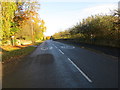
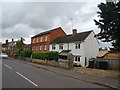
Main Street (B4035) in Upper Brailes
Looking northward in the direction of Shipston-on-Stour.
Image: © Peter Wood
Taken: 5 Nov 2017
0.04 miles
3
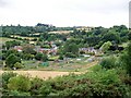
Upper Brailes
The view of the village from the top of Castle Hill a prehistoric burial ground that was used as the mound for a 12th century motte-and-bailey castle.
Image: © Michael Dibb
Taken: 26 Jul 2010
0.04 miles
4
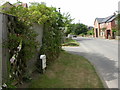
Upper Brailes, milepost
On High Street, renovated wooden post with iron plate, giving distances to Banbury and Shipston.
Image: © Mike Faherty
Taken: 2 Jul 2010
0.07 miles
5
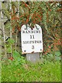
Old Milepost, High Street, Upper Brailes
Metal plate attached to wooden post by the B4035, in parish of Brailes (Stratford on Avon District), High Street, at junction with Hill Lane, in front of Old Farmhouse on verge, on West side of road. Brailes plate on wood erected by the Banbury, Brailes & Barcheston Turnpike Trust in the 19th century. One of very few remaining wooden posts.
Inscription reads:-
BRAILES
BANBURY
11
SHIPSTON
3
Grade II listed. List Entry Number: 1024388
https://historicengland.org.uk/listing/the-list/list-entry/1024388
Milestone Society National ID: WA_BASP11.
Image: © Milestone Society
Taken: 6 Oct 2017
0.08 miles
7
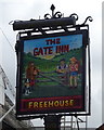
Sign for the Gate Inn, Upper Brailes
See Image] for context.
Image: © JThomas
Taken: 5 Oct 2019
0.08 miles
8
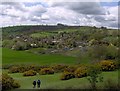
Brailes Allotments from Castle Hill
Taken during the annual 3 Hills Walk 2006.
Image: © Ian Merivale
Taken: 1 May 2006
0.10 miles
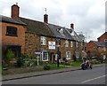
10
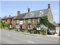
The Gate Inn, Upper Brailes
Yet another splendid Hook Norton pub.
Image: © al partington
Taken: 11 May 2006
0.10 miles