IMAGES TAKEN NEAR TO
Upper Brailes, BANBURY, OX15 5AT
Introduction
This page details the photographs taken nearby to OX15 5AT by members of the Geograph project.
The Geograph project started in 2005 with the aim of publishing, organising and preserving representative images for every square kilometre of Great Britain, Ireland and the Isle of Man.

There are currently over 7.5m images from over14,400 individuals and you can help contribute to the project by visiting https://www.geograph.org.uk
Image Map
Images are licensed for reuse under creativecommons.org/licenses/by-sa/2.0
Notes
- Clicking on the map will re-center to the selected point.
- The higher the marker number, the further away the image location is from the centre of the postcode.
Image Listing (40 Images Found)
Images are licensed for reuse under creativecommons.org/licenses/by-sa/2.0
Image
Details
Distance
1
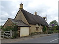
Thatched cottages on the B4035, Upper Brailes
Image: © JThomas
Taken: 5 Oct 2019
0.03 miles
2
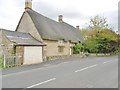
Upper Brailes, Old Forge
Thatched stone cottage on High Street.
Image: © Mike Faherty
Taken: 6 Oct 2017
0.03 miles
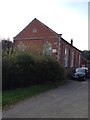
6
Upper Brailes Former Wesleyan Chapel
Now converted to Business Premises.
Image: © Ian Rob
Taken: 15 Jun 2017
0.07 miles
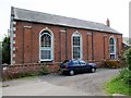
7

Upper Brailes, chapel
Methodist Chapel, on a lane off High Street; dated 1863.
Image: © Mike Faherty
Taken: 2 Jul 2010
0.07 miles
8
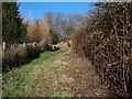
Climbing Gillett's Hill
The footpath leading to Borough Hill first steeply ascends Gillett's Hill.
Image: © Michael Dibb
Taken: 26 Dec 2009
0.08 miles
9
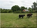
Upper Brailes, heifers
In a field off High Street.
Image: © Mike Faherty
Taken: 2 Jul 2010
0.08 miles