IMAGES TAKEN NEAR TO
Brailes, BANBURY, OX15 5AF
Introduction
This page details the photographs taken nearby to OX15 5AF by members of the Geograph project.
The Geograph project started in 2005 with the aim of publishing, organising and preserving representative images for every square kilometre of Great Britain, Ireland and the Isle of Man.

There are currently over 7.5m images from over14,400 individuals and you can help contribute to the project by visiting https://www.geograph.org.uk
Image Map (Loading...)


Getting Data...Please wait
Leaflet Map data © OpenStreetMap
Images are licensed for reuse under creativecommons.org/licenses/by-sa/2.0
Notes
- Clicking on the map will re-center to the selected point.
- The higher the marker number, the further away the image location is from the centre of the postcode.
Image Listing (11 Images Found)
Images are licensed for reuse under creativecommons.org/licenses/by-sa/2.0
Image
Details
Distance
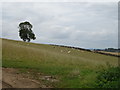
2
Gallow Hill Farm
On the road east from Lower Brailes.
Image: © Ian Rob
Taken: 18 Apr 2019
0.08 miles
4
![Gallow Hill Farm [4]](https://s0.geograph.org.uk/geophotos/03/05/53/3055344_5d412144_120x120.jpg)
Gallow Hill Farm [4]
Seen from the B4035 road, the main entrance to the farm is to the right of the first building which may once have been the farmhouse. The bridleway (now diverted to the east of the farm) used to start here and pass through the farm. The notice advising of the diversion of the bridleway is posted in the right hand ground window.
Image: © Michael Dibb
Taken: 30 Jun 2012
0.09 miles
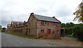
6
![Gallow Hill Farm [3]](https://s3.geograph.org.uk/geophotos/03/05/53/3055335_577f97fe_120x120.jpg)
Gallow Hill Farm [3]
The farm buildings are somewhat unusual, they look more like a factory than a farm. Here the view is looking north east along the B4035 with the older building nearer the camera. This older building would seem to be a seven bay open cart shed. Six of the bays have been bricked up.
Image: © Michael Dibb
Taken: 30 Jun 2012
0.11 miles
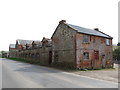
7
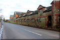
Buildings at Gallow Hill farm
This extensive range of brick and stone built farm buildings face onto the B4035 road in the extreme south east corner of the grid square.
Image: © Nigel Mykura
Taken: 12 Mar 2018
0.13 miles
8
![Gallow Hill Farm [1]](https://s2.geograph.org.uk/geophotos/03/05/53/3055314_a7814c34_120x120.jpg)
Gallow Hill Farm [1]
The farm buildings are somewhat unusual. This view of the roofs is seen from the bridleway that has been diverted around the farm to the east.
Image: © Michael Dibb
Taken: 30 Jun 2012
0.13 miles
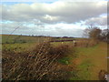
9
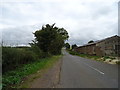
B4035 beside Gallow Hill Farm
Towards Swalcliffe.
Image: © JThomas
Taken: 5 Oct 2019
0.14 miles
10
![Gallow Hill Farm [2]](https://s2.geograph.org.uk/geophotos/03/05/53/3055326_915664ad_120x120.jpg)
Gallow Hill Farm [2]
The farm buildings are somewhat unusual, they look more like a factory than a farm. Here the view is looking south west along the B4035 with the newer buildings nearer the camera.
Image: © Michael Dibb
Taken: 30 Jun 2012
0.15 miles