IMAGES TAKEN NEAR TO
Bloxham Grove Road, OX15 4UL
Introduction
This page details the photographs taken nearby to Bloxham Grove Road, OX15 4UL by members of the Geograph project.
The Geograph project started in 2005 with the aim of publishing, organising and preserving representative images for every square kilometre of Great Britain, Ireland and the Isle of Man.

There are currently over 7.5m images from over14,400 individuals and you can help contribute to the project by visiting https://www.geograph.org.uk
Image Map (Loading...)


Getting Data...Please wait
Leaflet Map data © OpenStreetMap
Images are licensed for reuse under creativecommons.org/licenses/by-sa/2.0
Notes
- Clicking on the map will re-center to the selected point.
- The higher the marker number, the further away the image location is from the centre of the postcode.
Image Listing (18 Images Found)
Images are licensed for reuse under creativecommons.org/licenses/by-sa/2.0
Image
Details
Distance
1
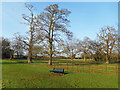
Bench in the Park, Bodicote
Very little separates Bodicote village from southern Banbury. Just here it is only this small park that comes between the two.
Image: © Des Blenkinsopp
Taken: 17 Dec 2018
0.06 miles
3
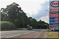
Oxford Road, Bodicote
By the Esso garage, which doesn't have a toilet.
Image: © David Howard
Taken: 1 Aug 2021
0.14 miles

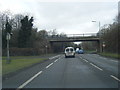
6
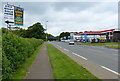
Petrol station on Oxford Road, Banbury
Image: © Mat Fascione
Taken: 23 May 2015
0.16 miles
7
By the Esso petrol station on Oxford Road, Bodicote
Image: © David Howard
Taken: 1 Aug 2021
0.16 miles
8
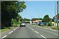
A4260 Oxford Road
Towards Banbury town centre.
Image: © Robin Webster
Taken: 18 Jul 2021
0.18 miles
9
Oxford Road, Bodicote
The A4620 towards Banbury.
Image: © JThomas
Taken: 28 Sep 2019
0.20 miles
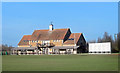
10
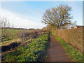
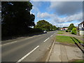
Salt Way, Bodicote
A bridle path and cycleway which for the time being marks the boundary between suburban Banbury and farmland round Bodicote. The name suggests it might be an ancient route.
Image: © Des Blenkinsopp
Taken: 17 Dec 2018
0.21 miles