IMAGES TAKEN NEAR TO
Sunrise Drive, OX15 4UG
Introduction
This page details the photographs taken nearby to Sunrise Drive, OX15 4UG by members of the Geograph project.
The Geograph project started in 2005 with the aim of publishing, organising and preserving representative images for every square kilometre of Great Britain, Ireland and the Isle of Man.

There are currently over 7.5m images from over14,400 individuals and you can help contribute to the project by visiting https://www.geograph.org.uk
Image Map (Loading...)


Getting Data...Please wait
Leaflet Map data © OpenStreetMap
Images are licensed for reuse under creativecommons.org/licenses/by-sa/2.0
Notes
- Clicking on the map will re-center to the selected point.
- The higher the marker number, the further away the image location is from the centre of the postcode.
Image Listing (7 Images Found)
Images are licensed for reuse under creativecommons.org/licenses/by-sa/2.0
Image
Details
Distance

3
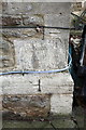
Benchmark on Cotefield House, Banbury Road
Ordnance Survey cut mark benchmark described on the Bench Mark Database at http://www.bench-marks.org.uk/bm52301
Image: © Roger Templeman
Taken: 29 Oct 2013
0.20 miles
4
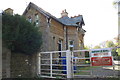
Cotefield House, Banbury Road
There is an OS benchmark Image on the stone quoin visible through the metal gate between the 2nd and 3rd bars from the top
Image: © Roger Templeman
Taken: 29 Oct 2013
0.20 miles
5
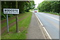
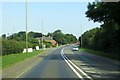
Oxford Road at Bodicote
Bodicote is a village on the southern edge of Banbury.
Image: © Mat Fascione
Taken: 23 May 2015
0.22 miles