IMAGES TAKEN NEAR TO
Coleman Close, BANBURY, OX15 4SR
Introduction
This page details the photographs taken nearby to Coleman Close, OX15 4SR by members of the Geograph project.
The Geograph project started in 2005 with the aim of publishing, organising and preserving representative images for every square kilometre of Great Britain, Ireland and the Isle of Man.

There are currently over 7.5m images from over14,400 individuals and you can help contribute to the project by visiting https://www.geograph.org.uk
Image Map (Loading...)


Getting Data...Please wait
Leaflet Map data © OpenStreetMap
Images are licensed for reuse under creativecommons.org/licenses/by-sa/2.0
Notes
- Clicking on the map will re-center to the selected point.
- The higher the marker number, the further away the image location is from the centre of the postcode.
Image Listing (3 Images Found)
Images are licensed for reuse under creativecommons.org/licenses/by-sa/2.0
Image
Details
Distance
1
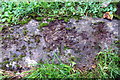
Benchmark on culvert beside Tadmarton Road
Ordnance Survey rivet benchmark described on the Bench Mark Database at http://www.bench-marks.org.uk/bm90089
Image: © Roger Templeman
Taken: 27 Oct 2017
0.15 miles
2
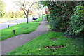
Tadmarton Road, looking southeast
There is an OS benchmark Image on the concrete slab in the foreground: this was at the end of a culvert for an open ditch which appears to have been piped
Image: © Roger Templeman
Taken: 27 Oct 2017
0.18 miles
3
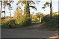
Track to 'Firs Hill' from Tadmarton Road
Image: © Roger Templeman
Taken: 27 Oct 2017
0.19 miles