IMAGES TAKEN NEAR TO
Queen Street, BANBURY, OX15 4QQ
Introduction
This page details the photographs taken nearby to Queen Street, OX15 4QQ by members of the Geograph project.
The Geograph project started in 2005 with the aim of publishing, organising and preserving representative images for every square kilometre of Great Britain, Ireland and the Isle of Man.

There are currently over 7.5m images from over14,400 individuals and you can help contribute to the project by visiting https://www.geograph.org.uk
Image Map (Loading...)


Getting Data...Please wait
Leaflet Map data © OpenStreetMap
Images are licensed for reuse under creativecommons.org/licenses/by-sa/2.0
Notes
- Clicking on the map will re-center to the selected point.
- The higher the marker number, the further away the image location is from the centre of the postcode.
Image Listing (169 Images Found)
Images are licensed for reuse under creativecommons.org/licenses/by-sa/2.0
Image
Details
Distance
1
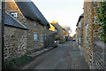
Kings Road, Bloxham
Once this was the main road through the village. It is not very wide.
Image: © Bill Boaden
Taken: 27 Jan 2022
0.06 miles
4
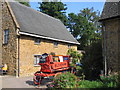
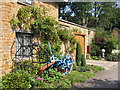
Bloxham Village Museum
This old fire appliance is advertising the village museum in the building behind just off Church Street .
Image: © David Stowell
Taken: 10 Sep 2006
0.10 miles
5
Bloxham Village Museum
A couple of the displays and the flower beds in front of the museum. According to the label the blue machinery is a potato harvester from around 1940.
Image: © David Stowell
Taken: 10 Sep 2006
0.10 miles
6
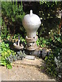
Hydraulic Ram pump
On display at the Image This is a very simple but effective device for pumping a water supply uphill from a stream. For one "in the wild" see Image
Image: © David Stowell
Taken: 10 Sep 2006
0.10 miles
7
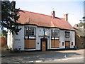
The Hawk and Partridge, Bloxham
Sadly this pub, situated opposite the church, seems to have seen better days.
Image: © David Stowell
Taken: 10 Sep 2006
0.10 miles
8
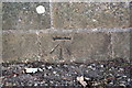
Benchmark on Cumberford Hill bridge parapet
Ordnance Survey cut mark benchmark described on the Bench Mark Database at http://www.bench-marks.org.uk/bm90319
Image: © Roger Templeman
Taken: 27 Oct 2017
0.10 miles
9
Parapet of bridge over brook at junction of Tadmarton Road and Cumberford Hill
There is an OS benchmark Image at the base of the parapet over the centre of the brook
Image: © Roger Templeman
Taken: 27 Oct 2017
0.10 miles
10
Housing conversion
This building in Church Street appears to have been a school or community building prior to conversion.
Image: © David Stowell
Taken: 10 Sep 2006
0.11 miles