IMAGES TAKEN NEAR TO
Courtington Lane, BANBURY, OX15 4HT
Introduction
This page details the photographs taken nearby to Courtington Lane, OX15 4HT by members of the Geograph project.
The Geograph project started in 2005 with the aim of publishing, organising and preserving representative images for every square kilometre of Great Britain, Ireland and the Isle of Man.

There are currently over 7.5m images from over14,400 individuals and you can help contribute to the project by visiting https://www.geograph.org.uk
Image Map
Images are licensed for reuse under creativecommons.org/licenses/by-sa/2.0
Notes
- Clicking on the map will re-center to the selected point.
- The higher the marker number, the further away the image location is from the centre of the postcode.
Image Listing (3 Images Found)
Images are licensed for reuse under creativecommons.org/licenses/by-sa/2.0
Image
Details
Distance
1
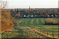
Path down to Bloxham
Looking down from Hobb Hill in low winter sun.
Image: © Bill Boaden
Taken: 27 Jan 2022
0.10 miles
2
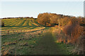
Path up to Hobb Hill
The low winter sun is highlighting the cultivation strips to the left.
Image: © Bill Boaden
Taken: 27 Jan 2022
0.12 miles
3
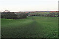
Path down to Ells Farm
Viewed in winter evening light from Hobb Hill. The valley of Sor Brook is laid out below.
Image: © Bill Boaden
Taken: 27 Jan 2022
0.19 miles