IMAGES TAKEN NEAR TO
Hobby Road, BANBURY, OX15 4GH
Introduction
This page details the photographs taken nearby to Hobby Road, OX15 4GH by members of the Geograph project.
The Geograph project started in 2005 with the aim of publishing, organising and preserving representative images for every square kilometre of Great Britain, Ireland and the Isle of Man.

There are currently over 7.5m images from over14,400 individuals and you can help contribute to the project by visiting https://www.geograph.org.uk
Image Map (Loading...)


Getting Data...Please wait
Leaflet Map data © OpenStreetMap
Images are licensed for reuse under creativecommons.org/licenses/by-sa/2.0
Notes
- Clicking on the map will re-center to the selected point.
- The higher the marker number, the further away the image location is from the centre of the postcode.
Image Listing (12 Images Found)
Images are licensed for reuse under creativecommons.org/licenses/by-sa/2.0
Image
Details
Distance
1
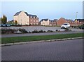
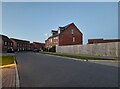
Songthrush Road from Longford Park Road
Image: © David Howard
Taken: 17 Oct 2021
0.07 miles
2
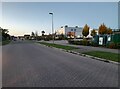
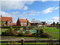
Longford Park Road, Bodicote
The building on the right is a school
Image: © David Howard
Taken: 17 Oct 2021
0.13 miles
3
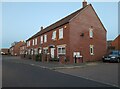
Terrace of houses on Longford Park Road, Bodicote
Why so many new houses have to look like Victorian railway cottages is a mystery to me. Many are no bigger either.
Image: © David Howard
Taken: 17 Oct 2021
0.13 miles


9
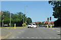
Lights, A4260 Oxford Road, Bodicote
Towards Banbury town centre.
Image: © Robin Webster
Taken: 18 Jul 2021
0.23 miles
10
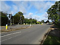
Oxford Road, Bodicote
Junction with Weeping Cross.
Image: © JThomas
Taken: 28 Sep 2019
0.23 miles