IMAGES TAKEN NEAR TO
Wards Crescent, BANBURY, OX15 4DY
Introduction
This page details the photographs taken nearby to Wards Crescent, OX15 4DY by members of the Geograph project.
The Geograph project started in 2005 with the aim of publishing, organising and preserving representative images for every square kilometre of Great Britain, Ireland and the Isle of Man.

There are currently over 7.5m images from over14,400 individuals and you can help contribute to the project by visiting https://www.geograph.org.uk
Image Map
Images are licensed for reuse under creativecommons.org/licenses/by-sa/2.0
Notes
- Clicking on the map will re-center to the selected point.
- The higher the marker number, the further away the image location is from the centre of the postcode.
Image Listing (65 Images Found)
Images are licensed for reuse under creativecommons.org/licenses/by-sa/2.0
Image
Details
Distance
1
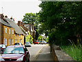
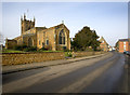
Church Street, Bodicote
It seems likely that the street got its name from the nearby St John the Baptist Church rather than the Methodist Church as that one is round the corner in East Street.
Image: © Brian Robert Marshall
Taken: 2 Jun 2010
0.11 miles
2
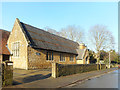
Bodicote Church House
Adjacent to the parish church, it looks like it might have been the village school at one time.
Image: © Des Blenkinsopp
Taken: 17 Dec 2018
0.13 miles
3
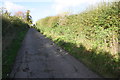
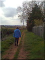
Lane from Bodicote Mill towards the Church
Buried in the hedge on the right hand side of the lane is a metal gate with wooden gatepost Image which the 1973 map indicates to be the access point to allotment gardens.
Image: © Roger Templeman
Taken: 29 Oct 2013
0.13 miles
4
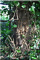
Gatepost at entrance to former allotments from lane to Mill
There may be the remains of an Ordnance Survey cut mark benchmark on the post: see description on the Bench Mark Database at http://www.bench-marks.org.uk/bm52362
Image: © Roger Templeman
Taken: 29 Oct 2013
0.14 miles
5
St John the Baptist Parish Church, Bodicote
Looking north up the High Street, the Pub is the Plough. The junction with East Street is to the right by the red brick house.
Image: © Ben Nicholson
Taken: 24 Jan 2006
0.14 miles
6
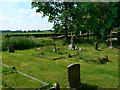
Graves in the churchyard, the Parish Church of St John the Baptist, Bodicote
The churchyard contains numerous graves, many Victorian from what I saw. A pleasant place to spend eternity.
Image: © Brian Robert Marshall
Taken: 2 Jun 2010
0.15 miles
7
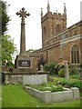
Bodicote and War Memorial
St John the Baptist Church and War Memorial, Bodicote.
Image: © Snidge
Taken: 22 May 2007
0.15 miles
8
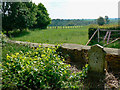
The western edge of the churchyard, the Parish Church of St John the Baptist, Bodicote
Beyond the wall and gravestone lies a paddock and, if you look hard enough, you can see the spire of St Mary's Church, Bloxham 3.5 kilometres away http://www.geograph.org.uk/photo/1893097 the beauty of which strikes most photographers of it dumb.
Image: © Brian Robert Marshall
Taken: 2 Jun 2010
0.15 miles
10
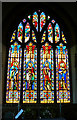
Stained glass window, the Parish Church of St John the Baptist, Bodicote
This is at the east end of the church above the altar. The four main windows are linked by the inscriptions at the bottom and commemorate the departure from this life of a gentleman named George Warriner, late of Bloxham Grove aged 62, in 1845. George was the father of the curate responsible for the restoration of the church. The figures appear to be Jesus Christ and at least three of his disciples. More about the church on their website http://www.bodicotechurch.org/
Image: © Brian Robert Marshall
Taken: 2 Jun 2010
0.16 miles