IMAGES TAKEN NEAR TO
Town Furlong, BANBURY, OX15 4DP
Introduction
This page details the photographs taken nearby to Town Furlong, OX15 4DP by members of the Geograph project.
The Geograph project started in 2005 with the aim of publishing, organising and preserving representative images for every square kilometre of Great Britain, Ireland and the Isle of Man.

There are currently over 7.5m images from over14,400 individuals and you can help contribute to the project by visiting https://www.geograph.org.uk
Image Map (Loading...)


Getting Data...Please wait
Leaflet Map data © OpenStreetMap
Images are licensed for reuse under creativecommons.org/licenses/by-sa/2.0
Notes
- Clicking on the map will re-center to the selected point.
- The higher the marker number, the further away the image location is from the centre of the postcode.
Image Listing (68 Images Found)
Images are licensed for reuse under creativecommons.org/licenses/by-sa/2.0
Image
Details
Distance
1
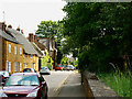
Church Street, Bodicote
It seems likely that the street got its name from the nearby St John the Baptist Church rather than the Methodist Church as that one is round the corner in East Street.
Image: © Brian Robert Marshall
Taken: 2 Jun 2010
0.04 miles
2
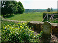
The western edge of the churchyard, the Parish Church of St John the Baptist, Bodicote
Beyond the wall and gravestone lies a paddock and, if you look hard enough, you can see the spire of St Mary's Church, Bloxham 3.5 kilometres away http://www.geograph.org.uk/photo/1893097 the beauty of which strikes most photographers of it dumb.
Image: © Brian Robert Marshall
Taken: 2 Jun 2010
0.04 miles
3
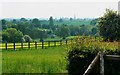
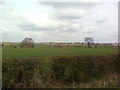
Paddock near the Parish Church of St John the Baptist, Bodicote
There were some horses about but I didn't photograph them. In the far distance is the spire of St Mary's Church in Bloxham http://www.geograph.org.uk/photo/1893097 That church has, unfortunately, attracted the attention of the usual dimbulbs and holy rollers who take snaps of churches and then submit them without the benefit of any sort of meaningful description. My advice? Ignore those shots and stick to those where gathering numbers or shots for their next 'book' isn't top of the submitters' agenda http://www.geograph.org.uk/search.php?i=13110522&displayclass=full
Image: © Brian Robert Marshall
Taken: 2 Jun 2010
0.05 miles
4
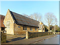
Bodicote Church House
Adjacent to the parish church, it looks like it might have been the village school at one time.
Image: © Des Blenkinsopp
Taken: 17 Dec 2018
0.06 miles
5
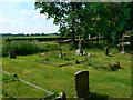
Graves in the churchyard, the Parish Church of St John the Baptist, Bodicote
The churchyard contains numerous graves, many Victorian from what I saw. A pleasant place to spend eternity.
Image: © Brian Robert Marshall
Taken: 2 Jun 2010
0.06 miles
7
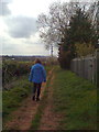
Looking towards Bloxham from Bloxham Grove Road
Image: © Dave Favis-Mortlock
Taken: 14 Apr 2012
0.09 miles
8

Inside St John the Baptist, Bodicote (a)
Image: © Basher Eyre
Taken: 19 Nov 2017
0.09 miles
9

St John the Baptist, Bodicote: font (b)
Image: © Basher Eyre
Taken: 19 Nov 2017
0.09 miles
10

St John the Baptist, Bodicote: font (a)
Image: © Basher Eyre
Taken: 19 Nov 2017
0.09 miles