IMAGES TAKEN NEAR TO
Red House Road, BANBURY, OX15 4AZ
Introduction
This page details the photographs taken nearby to Red House Road, OX15 4AZ by members of the Geograph project.
The Geograph project started in 2005 with the aim of publishing, organising and preserving representative images for every square kilometre of Great Britain, Ireland and the Isle of Man.

There are currently over 7.5m images from over14,400 individuals and you can help contribute to the project by visiting https://www.geograph.org.uk
Image Map (Loading...)


Getting Data...Please wait
Leaflet Map data © OpenStreetMap
Images are licensed for reuse under creativecommons.org/licenses/by-sa/2.0
Notes
- Clicking on the map will re-center to the selected point.
- The higher the marker number, the further away the image location is from the centre of the postcode.
Image Listing (37 Images Found)
Images are licensed for reuse under creativecommons.org/licenses/by-sa/2.0
Image
Details
Distance
1
Back of #10 Walton Close
There is an OS benchmark Image on the 45-degree corner wall, right of the wooden fence panel
Image: © Roger Templeman
Taken: 29 Oct 2013
0.13 miles
2
Benchmark on #10 Walton Close
Ordnance Survey cut mark described on the Bench Mark Database at http://www.bench-marks.org.uk/bm52356
Image: © Roger Templeman
Taken: 29 Oct 2013
0.13 miles
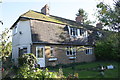
3
Woodlands, Weeping Cross
There is an OS benchmark Image on the near corner front face of the house right of the right hand end of the wooden fence and behind the bush
Image: © Roger Templeman
Taken: 29 Oct 2013
0.18 miles
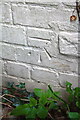
4
Benchmark on #1 Woodlands, Weeping Cross
Ordnance Survey cut mark described on the Bench Mark Database at http://www.bench-marks.org.uk/bm52355
Image: © Roger Templeman
Taken: 29 Oct 2013
0.18 miles
5
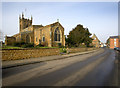
St John the Baptist Parish Church, Bodicote
Looking north up the High Street, the Pub is the Plough. The junction with East Street is to the right by the red brick house.
Image: © Ben Nicholson
Taken: 24 Jan 2006
0.18 miles
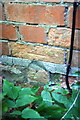
6
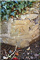
Benchmark on Draycott House, East Street
Ordnance Survey cut mark benchmark described on the Bench Mark Database at http://www.bench-marks.org.uk/bm52357
Image: © Roger Templeman
Taken: 29 Oct 2013
0.19 miles
7
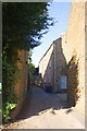
Chapel Lane from East Street
The house on the left is Draycott House (with an OS benchmark Image on the corner at the bottom left of the image) and the white door on the right is the entrance to Rhubarb Cottage
Image: © Roger Templeman
Taken: 29 Oct 2013
0.19 miles
8
Chapel Lane, Bodicote
Very narrow at this end but widens out a short way along.
Image: © Des Blenkinsopp
Taken: 17 Dec 2018
0.19 miles
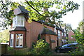
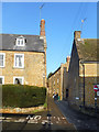
10
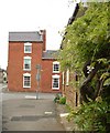
East Street
House on the corner of East Street and High Street, Bodicote.
Image: © Snidge
Taken: 22 May 2007
0.22 miles