IMAGES TAKEN NEAR TO
Earls Lane, BANBURY, OX15 0TH
Introduction
This page details the photographs taken nearby to Earls Lane, OX15 0TH by members of the Geograph project.
The Geograph project started in 2005 with the aim of publishing, organising and preserving representative images for every square kilometre of Great Britain, Ireland and the Isle of Man.

There are currently over 7.5m images from over14,400 individuals and you can help contribute to the project by visiting https://www.geograph.org.uk
Image Map (Loading...)


Getting Data...Please wait
Leaflet Map data © OpenStreetMap
Images are licensed for reuse under creativecommons.org/licenses/by-sa/2.0
Notes
- Clicking on the map will re-center to the selected point.
- The higher the marker number, the further away the image location is from the centre of the postcode.
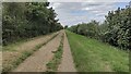
Image Listing (91 Images Found)
Images are licensed for reuse under creativecommons.org/licenses/by-sa/2.0
Image
Details
Distance
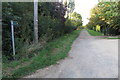
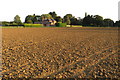
4
Earl's Lane
At the junction with Clifton Road to the east of Deddington.
Image: © Dennis Turner
Taken: 8 Apr 2006
0.12 miles
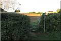
6
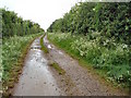
Footpath from Earl's Lane
This track leads to a field of cows and not much else!
Image: © Duncan Lilly
Taken: 28 May 2007
0.13 miles

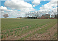
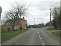
10
Path to Paper Mill Cottages
From Earl's Lane the path to Paper Mill Cottages
Image: © Shaun Ferguson
Taken: 26 Aug 2021
0.15 miles