
IMAGES TAKEN NEAR TO
Chapmans Lane, BANBURY, OX15 0SU
Introduction
This page details the photographs taken nearby to Chapmans Lane, OX15 0SU by members of the Geograph project.
The Geograph project started in 2005 with the aim of publishing, organising and preserving representative images for every square kilometre of Great Britain, Ireland and the Isle of Man.

There are currently over 7.5m images from over14,400 individuals and you can help contribute to the project by visiting https://www.geograph.org.uk
Image Map
Images are licensed for reuse under creativecommons.org/licenses/by-sa/2.0
Notes
- Clicking on the map will re-center to the selected point.
- The higher the marker number, the further away the image location is from the centre of the postcode.
Image Listing (18 Images Found)
Images are licensed for reuse under creativecommons.org/licenses/by-sa/2.0
Image
Details
Distance
1
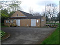
Deddington Telephone Exchange, Oxon
Situated in Chapmans Lane, off the A4260 Oxford Road, this TE rather resembles a Scout or Guide Hut. Besides Deddington, this TE also serves Barford St Michael, Clifton and Hempton nearby. Cable drums can be seen in front of this TE. Its numbering range is (01869) 337xxx, 338xxx, the (01869) referring to the Bicester group of TEs, and its postcode is OX15 0SU.
Image: © David Hillas
Taken: 27 Apr 2013
0.05 miles


5
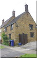
#6 New Street
Ordnance Survey records indicate there was a benchmark cut on the base quoin to the left of the blue plastic bin. A closeup of this stone Image may show the remains of the mark.
Image: © Roger Templeman
Taken: 16 May 2014
0.13 miles
6
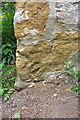
Possible remains of benchmark on #6 New Street
Ordnance Survey cut mark benchmark described on the Bench Mark Database at http://www.bench-marks.org.uk/bm57332
Image: © Roger Templeman
Taken: 16 May 2014
0.14 miles
7
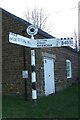
Direction Sign ? Signpost in Deddington parish
Located on the southwest side of the junction of St Thomas Street, Philcote Street and Hopcraft Lane in Deddington parish. 2 arms and annulus finial.
Milestone Society National ID: OX_SP4631B
Image: © John V Nicholls
Taken: 28 Sep 2009
0.17 miles

10

Deddington viewed from Plumdon Lane
A wide view across the valley.
Image: © Duncan Lilly
Taken: 1 Jun 2007
0.22 miles