IMAGES TAKEN NEAR TO
The Green, BANBURY, OX15 0RS
Introduction
This page details the photographs taken nearby to The Green, OX15 0RS by members of the Geograph project.
The Geograph project started in 2005 with the aim of publishing, organising and preserving representative images for every square kilometre of Great Britain, Ireland and the Isle of Man.

There are currently over 7.5m images from over14,400 individuals and you can help contribute to the project by visiting https://www.geograph.org.uk
Image Map (Loading...)


Getting Data...Please wait
Leaflet Map data © OpenStreetMap
Images are licensed for reuse under creativecommons.org/licenses/by-sa/2.0
Notes
- Clicking on the map will re-center to the selected point.
- The higher the marker number, the further away the image location is from the centre of the postcode.
Image Listing (17 Images Found)
Images are licensed for reuse under creativecommons.org/licenses/by-sa/2.0
Image
Details
Distance
1
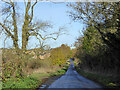
Netherworton Road
Towards Barford St Michael.
Image: © Robin Webster
Taken: 13 Nov 2016
0.14 miles
2
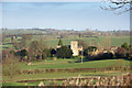
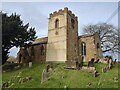
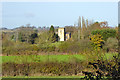
Barford St Michael Church
Taken from the Nether Worton Road, in the distance can be seen the spire of Bloxham Church.
Image: © Ben Nicholson
Taken: 5 Dec 2006
0.14 miles
4
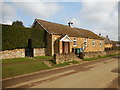
Barford St Michael Village Hall
On Lower Street.
Image: © Ian Rob
Taken: 25 Mar 2018
0.15 miles
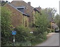
5
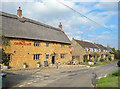
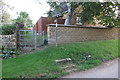
The George Inn
A 17th century thatched pub on Lower Street.
Image: © Des Blenkinsopp
Taken: 22 Sep 2020
0.16 miles
6
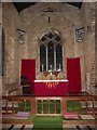
Barford St. Michael church
Unsurprisingly, St. Michael's.
Image: © Robin Webster
Taken: 13 Nov 2016
0.17 miles