IMAGES TAKEN NEAR TO
The Paddocks, BANBURY, OX15 0QN
Introduction
This page details the photographs taken nearby to The Paddocks, OX15 0QN by members of the Geograph project.
The Geograph project started in 2005 with the aim of publishing, organising and preserving representative images for every square kilometre of Great Britain, Ireland and the Isle of Man.

There are currently over 7.5m images from over14,400 individuals and you can help contribute to the project by visiting https://www.geograph.org.uk
Image Map (Loading...)


Getting Data...Please wait
Leaflet Map data © OpenStreetMap
Images are licensed for reuse under creativecommons.org/licenses/by-sa/2.0
Notes
- Clicking on the map will re-center to the selected point.
- The higher the marker number, the further away the image location is from the centre of the postcode.
Image Listing (113 Images Found)
Images are licensed for reuse under creativecommons.org/licenses/by-sa/2.0
Image
Details
Distance
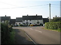
2
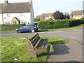
Seat at the western end of The Paddocks
Image: © Basher Eyre
Taken: 20 Sep 2008
0.04 miles
3
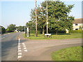
Phonebox on the corner of Windmill Street and the B4031
Image: © Basher Eyre
Taken: 20 Sep 2008
0.04 miles
5
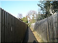
Short cut from The Daedings to the village
Taken on a glorious late December morning.
Image: © Basher Eyre
Taken: 29 Dec 2007
0.06 miles
7
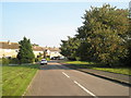
Looking northwards along Windmill Street
Image: © Basher Eyre
Taken: 20 Sep 2008
0.07 miles
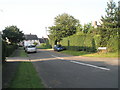
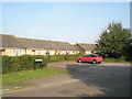
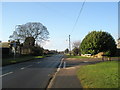
8
Junction of Murdock Close and the B4031
Image: © Basher Eyre
Taken: 20 Sep 2008
0.08 miles
9
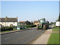
Tractor heading into B4031 on the B4031
Image: © Basher Eyre
Taken: 20 Sep 2008
0.08 miles
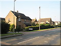
10
Junction of Gaveston Gardens and Hempton Road
Taken looking west on a wonderfully crisp late December morning.
Image: © Basher Eyre
Taken: 29 Dec 2007
0.09 miles