IMAGES TAKEN NEAR TO
Windmill Close, BANBURY, OX15 0QD
Introduction
This page details the photographs taken nearby to Windmill Close, OX15 0QD by members of the Geograph project.
The Geograph project started in 2005 with the aim of publishing, organising and preserving representative images for every square kilometre of Great Britain, Ireland and the Isle of Man.

There are currently over 7.5m images from over14,400 individuals and you can help contribute to the project by visiting https://www.geograph.org.uk
Image Map (Loading...)


Getting Data...Please wait
Leaflet Map data © OpenStreetMap
Images are licensed for reuse under creativecommons.org/licenses/by-sa/2.0
Notes
- Clicking on the map will re-center to the selected point.
- The higher the marker number, the further away the image location is from the centre of the postcode.
Image Listing (64 Images Found)
Images are licensed for reuse under creativecommons.org/licenses/by-sa/2.0
Image
Details
Distance
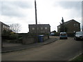
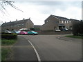
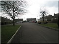
2
Junction of Windmill Close and The Daedings
Image: © Basher Eyre
Taken: 7 Apr 2010
0.04 miles
3
"Spring" in Mackley Close
I use the parentheses because it was the coldest Easter ever (Good Friday 29 March to Monday 1st April) and today was pretty much the same!
Image: © Basher Eyre
Taken: 2 Apr 2013
0.04 miles
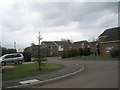
4
On the path from Windmill Street to Daeda's Wood (1)
Image: © Basher Eyre
Taken: 7 Apr 2015
0.04 miles
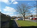
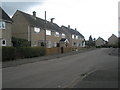
5
Looking towards the junction of Windmill Street and Windmill Close
Image: © Basher Eyre
Taken: 7 Apr 2010
0.05 miles
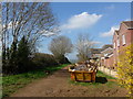
6
Footpath from The Daedings to Daeda's Wood
Image: © Basher Eyre
Taken: 2 Apr 2013
0.06 miles
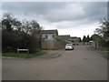
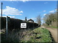
10
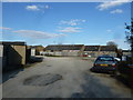
Yard between Windmill Street and Hempton Road
Image: © Basher Eyre
Taken: 2 Apr 2013
0.07 miles