IMAGES TAKEN NEAR TO
County View, BANBURY, OX15 0PZ
Introduction
This page details the photographs taken nearby to County View, OX15 0PZ by members of the Geograph project.
The Geograph project started in 2005 with the aim of publishing, organising and preserving representative images for every square kilometre of Great Britain, Ireland and the Isle of Man.

There are currently over 7.5m images from over14,400 individuals and you can help contribute to the project by visiting https://www.geograph.org.uk
Image Map
Images are licensed for reuse under creativecommons.org/licenses/by-sa/2.0
Notes
- Clicking on the map will re-center to the selected point.
- The higher the marker number, the further away the image location is from the centre of the postcode.
Image Listing (17 Images Found)
Images are licensed for reuse under creativecommons.org/licenses/by-sa/2.0
Image
Details
Distance
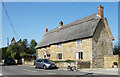
2
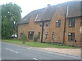
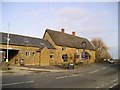
St Annes Residential Home Clifton
Typical honey coloured Horton Stoned building
Image: © Jake Mayo
Taken: 2 Jul 2005
0.09 miles
3
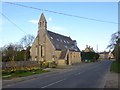
Clifton, converted church
Shown on old OS maps as St. James's, now, according to a nameplate, belonging to a lighting company.
Image: © Mike Faherty
Taken: 15 Mar 2014
0.10 miles
4
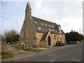
Clifton-Old Church
Converted to a Business premises.
Image: © Ian Rob
Taken: 25 Mar 2018
0.10 miles
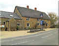
6
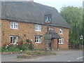
Duke of Cumberland's Head Public House
The most important building in Clifton.
Image: © Jake Mayo
Taken: 2 Jul 2005
0.14 miles
8
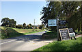
Home Farm, Clifton
Signs at the farm shop by the road towards Clifton.
Image: © Des Blenkinsopp
Taken: 22 Sep 2020
0.14 miles
9
The Duke of Cumberlands Head Pub, Clifton
Main Street, Clifton, Banbury, OX15 0PE close to the Oxford Canal.
Image: © canalandriversidepubs co uk
Taken: 5 Feb 2010
0.15 miles
10
The Duke of Cumberlands Head
This Grade II listed building has been recorded as a public house since 1774; in which century it was also remodelled. It may date from the previous one and has English Heritage Building ID: 243857.
Image: © Stuart Logan
Taken: 31 Mar 2013
0.15 miles