IMAGES TAKEN NEAR TO
Barford St. John, BANBURY, OX15 0PS
Introduction
This page details the photographs taken nearby to OX15 0PS by members of the Geograph project.
The Geograph project started in 2005 with the aim of publishing, organising and preserving representative images for every square kilometre of Great Britain, Ireland and the Isle of Man.

There are currently over 7.5m images from over14,400 individuals and you can help contribute to the project by visiting https://www.geograph.org.uk
Image Map
Images are licensed for reuse under creativecommons.org/licenses/by-sa/2.0
Notes
- Clicking on the map will re-center to the selected point.
- The higher the marker number, the further away the image location is from the centre of the postcode.
Image Listing (17 Images Found)
Images are licensed for reuse under creativecommons.org/licenses/by-sa/2.0
Image
Details
Distance
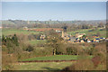
1
Barford St John
Church in background. Staddle stone in foreground.
Image: © Eileen Littler
Taken: 23 Sep 2011
0.02 miles
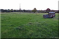
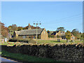
2
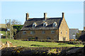
Manor Farm, Barford St. John
A grade II listed building, dated 1606.
Image: © Robin Webster
Taken: 13 Nov 2016
0.06 miles
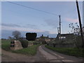
3
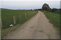
Barford St. John
Taken from across the valley below Hempton. Shows the east half of Barford St John with the Wireless Station and Bloxham Church behind.
Image: © Ben Nicholson
Taken: 5 Dec 2006
0.06 miles
5
Barford St John Church: church glimpsed beyond a yard
Image: © Basher Eyre
Taken: 19 Nov 2017
0.08 miles
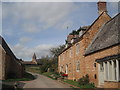
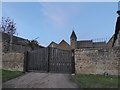
7
Buildings around Barford St John church
Image: © Robin Webster
Taken: 13 Nov 2016
0.08 miles
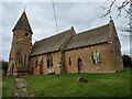
8
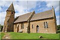
Barford St John church
Barford St John church was, in the words of Pevsner, 'drastically' restored in 1861 by G.E. Street. The original church dates from 12th century. The church is Grade II* listed.
Historic England description
Church. C12, C13 and C15. Restoration 1860's by G.E. Street. Regular coursed ironstone rubble. Stonesfield slate roof. Nave, chancel and south porch. Chancel: 3-light Perpendicular east window. Single lancet to north. Traceried window with square head, pointed arched doorway with plank door and 2-light lancet with limestone hood moulds to south. Nave: Two 2-light Perpendicular windows with square hood moulds and small 4-centred arched doorway to north. To south two 2-light Decorated windows with some renewed stonework. South doorway: Romanesque with zig zag decoration and jamb shafts with volute capitals, plank door. South porch: By Street, noted as an eccentric addition (Pevsner), octagonal tower with pyramidal roof and foliated circles to bell opening. Interior: Early English chancel and chancel arch. Fittings: Romanesque font, tub shaped on a Perpendicular base. Monument to James Belcher 1722 on north wall of chancel, decorated with cherubs. Date 1662 carved on highest stage of tower. (Buildings of England: Oxfordshire, 1974 p.445; V.C.H.: Oxfordshire, Vol IX, p.37).
Source: https://www.historicengland.org.uk/listing/the-list/list-entry/1046238
Image: © Philip Halling
Taken: 3 Aug 2016
0.09 miles