IMAGES TAKEN NEAR TO
OX15 0AJ
Introduction
This page details the photographs taken nearby to OX15 0AJ by members of the Geograph project.
The Geograph project started in 2005 with the aim of publishing, organising and preserving representative images for every square kilometre of Great Britain, Ireland and the Isle of Man.

There are currently over 7.5m images from over14,400 individuals and you can help contribute to the project by visiting https://www.geograph.org.uk
Image Map (Loading...)


Getting Data...Please wait
Leaflet Map data © OpenStreetMap
Images are licensed for reuse under creativecommons.org/licenses/by-sa/2.0
Notes
- Clicking on the map will re-center to the selected point.
- The higher the marker number, the further away the image location is from the centre of the postcode.
Image Listing (19 Images Found)
Images are licensed for reuse under creativecommons.org/licenses/by-sa/2.0
Image
Details
Distance
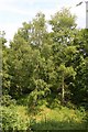
2
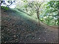
Defensive bank at Deddington motte and bailey castle
This castle is said to have been built by Bishop Odo, the brother of William the Conqueror. https://historicengland.org.uk/listing/the-list/list-entry/1014749
Image: © Sandy Gerrard
Taken: 27 Sep 2020
0.12 miles
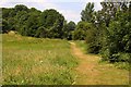
10
Earl's Lane
At the junction with Clifton Road to the east of Deddington.
Image: © Dennis Turner
Taken: 8 Apr 2006
0.18 miles