IMAGES TAKEN NEAR TO
Oxford Road, BANBURY, OX15 0AG
Introduction
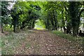
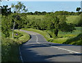
This page details the photographs taken nearby to Oxford Road, OX15 0AG by members of the Geograph project.
The Geograph project started in 2005 with the aim of publishing, organising and preserving representative images for every square kilometre of Great Britain, Ireland and the Isle of Man.

There are currently over 7.5m images from over14,400 individuals and you can help contribute to the project by visiting https://www.geograph.org.uk
Image Map
Images are licensed for reuse under creativecommons.org/licenses/by-sa/2.0
Notes
- Clicking on the map will re-center to the selected point.
- The higher the marker number, the further away the image location is from the centre of the postcode.
Image Listing (7 Images Found)
Images are licensed for reuse under creativecommons.org/licenses/by-sa/2.0
Image
Details
Distance
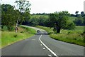
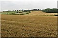
1
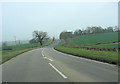
Oxford Road south of Dedington
This is also called the A4260.
Image: © Stuart Logan
Taken: 11 Nov 2011
0.07 miles
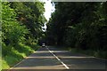
6
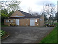
Deddington Telephone Exchange, Oxon
Situated in Chapmans Lane, off the A4260 Oxford Road, this TE rather resembles a Scout or Guide Hut. Besides Deddington, this TE also serves Barford St Michael, Clifton and Hempton nearby. Cable drums can be seen in front of this TE. Its numbering range is (01869) 337xxx, 338xxx, the (01869) referring to the Bicester group of TEs, and its postcode is OX15 0SU.
Image: © David Hillas
Taken: 27 Apr 2013
0.23 miles