IMAGES TAKEN NEAR TO
Pegasus Grange, White House Road, OXFORD, OX1 4QE
Introduction
This page details the photographs taken nearby to Pegasus Grange, White House Road, OX1 4QE by members of the Geograph project.
The Geograph project started in 2005 with the aim of publishing, organising and preserving representative images for every square kilometre of Great Britain, Ireland and the Isle of Man.

There are currently over 7.5m images from over14,400 individuals and you can help contribute to the project by visiting https://www.geograph.org.uk
Image Map
Images are licensed for reuse under creativecommons.org/licenses/by-sa/2.0
Notes
- Clicking on the map will re-center to the selected point.
- The higher the marker number, the further away the image location is from the centre of the postcode.
Image Listing (325 Images Found)
Images are licensed for reuse under creativecommons.org/licenses/by-sa/2.0
Image
Details
Distance
2
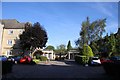
The courtyard in Pegasus Court
Pegasus Court is built on the site of Oxford City's Whitehouse Ground.
Image: © Steve Daniels
Taken: 22 Sep 2012
0.02 miles
3
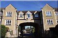
Pegasus Court in Whitehouse Road
Pegasus Court is built on the site of Oxford City's Whitehouse Ground.
Image: © Steve Daniels
Taken: 22 Sep 2012
0.02 miles
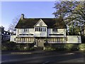
4
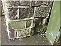
The White House, Abingdon Road at Whitehouse Road junction
There is an OS benchmark Image on the wall corner left of the BT cabinet
Image: © Roger Templeman
Taken: 28 Feb 2017
0.03 miles
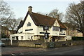
5
The White House on Abingdon Road
The White House is currently closed.
Image: © Steve Daniels
Taken: 27 Nov 2019
0.03 miles
6
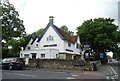
The White House, Oxford
On Abingdon Road.
See Image] for sign.
Image: © JThomas
Taken: 26 Jul 2022
0.03 miles
7
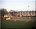
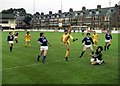
The Whitehouse Ground, Oxford
Oxford City played here until they were evicted by the landlords in 1988. There is a complex of retirement homes on the site now.
Image: © Steve Daniels
Taken: 5 May 1980
0.03 miles
8
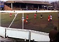
The Main Stand at the Whitehouse Ground
Image: © Steve Daniels
Taken: 14 Feb 1981
0.03 miles
9
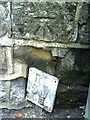
Benchmark on wall outside Folly Bridge Inn
Ordnance Survey cut mark benchmark described on the Bench Mark Database at http://www.bench-marks.org.uk/bm24307.
Image: © Roger Templeman
Taken: 15 Sep 2010
0.03 miles