IMAGES TAKEN NEAR TO
Western Road, OXFORD, OX1 4LG
Introduction
This page details the photographs taken nearby to Western Road, OX1 4LG by members of the Geograph project.
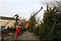
The Geograph project started in 2005 with the aim of publishing, organising and preserving representative images for every square kilometre of Great Britain, Ireland and the Isle of Man.

There are currently over 7.5m images from over14,400 individuals and you can help contribute to the project by visiting https://www.geograph.org.uk
Image Map
Images are licensed for reuse under creativecommons.org/licenses/by-sa/2.0
Notes
- Clicking on the map will re-center to the selected point.
- The higher the marker number, the further away the image location is from the centre of the postcode.
Image Listing (384 Images Found)
Images are licensed for reuse under creativecommons.org/licenses/by-sa/2.0
Image
Details
Distance
1
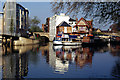
River Isis (Thames), Oxford
Showing the river just downstream from Folly Bridge, above the confluence with the Cherwell.
Image: © Stephen McKay
Taken: 4 May 2006
0.03 miles
2
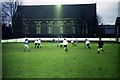
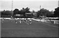
St Matthew's Church behind the Whitehouse Ground
Image: © Steve Daniels
Taken: 20 Dec 1980
0.03 miles
4
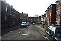
Thames Path in Oxford
The River Thames is to the right of the trees, on the left is Brook Street.
Image: © Mat Fascione
Taken: 15 Jun 2015
0.05 miles
7
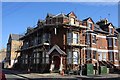
The former Marlborough House
The pub is undergoing conversion to housing.
Image: © Steve Daniels
Taken: 22 Sep 2012
0.06 miles
8

Tiles on the former Marlborough House
The pub used to be owned by Halls of Oxford (part of Ind Coope).
Image: © Steve Daniels
Taken: 22 Sep 2012
0.06 miles
9
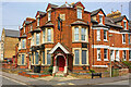
Marlborough House
Public House, Western Road, Oxford.
Image: © Wayland Smith
Taken: 24 Apr 2010
0.06 miles
10
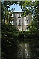
Oxford: building at Folly Bridge
This eighteenth century house stands on the Abingdon Road just south of Folly Bridge, straddling a small backwater of the Thames. The towpath following the main river crosses the bottom end of the backwater on a footbridge from which the photograph is taken: the road frontage is on the far side of the house.
Image: © Christopher Hilton
Taken: 23 Jun 2009
0.06 miles