IMAGES TAKEN NEAR TO
Stratton Way, ABINGDON, OX14 5TS
Introduction
This page details the photographs taken nearby to Stratton Way, OX14 5TS by members of the Geograph project.
The Geograph project started in 2005 with the aim of publishing, organising and preserving representative images for every square kilometre of Great Britain, Ireland and the Isle of Man.

There are currently over 7.5m images from over14,400 individuals and you can help contribute to the project by visiting https://www.geograph.org.uk
Image Map
Images are licensed for reuse under creativecommons.org/licenses/by-sa/2.0
Notes
- Clicking on the map will re-center to the selected point.
- The higher the marker number, the further away the image location is from the centre of the postcode.
Image Listing (558 Images Found)
Images are licensed for reuse under creativecommons.org/licenses/by-sa/2.0
Image
Details
Distance
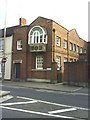
2
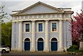
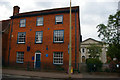
Abingdon Baptist Church
The church building was erected in 1841.
Image: © Steve Daniels
Taken: 10 Apr 2014
0.02 miles
3
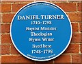
Blue plaque to Daniel Turner
The plaque is on 35 Ock Street in Abingdon. The liturgy composed by Daniel Turner in the study is still used in the Baptist communion worldwide.
Image: © Steve Daniels
Taken: 10 Apr 2014
0.04 miles
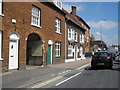
4
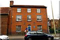
35 Ock Street in Abingdon
The blue plaque is on 35 Ock Street in Abingdon. The liturgy composed by Daniel Turner in the study is still used in the Baptist communion worldwide.
Image: © Steve Daniels
Taken: 10 Apr 2014
0.04 miles
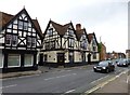
5
Abingdon: house of Baptist theologian Daniel Turner
The house, 35 Ock Street, was for fifty years the home of Daniel Turner (1710-1798), Baptist theologian, minister and hymn-writer: the blue plaque can be seen in detail at Image Beyond, to the right, the Baptist church.
Image: © Christopher Hilton
Taken: 28 May 2017
0.04 miles
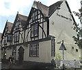
7
Abingdon, Brewery Tap
2012 Good Beer Guide-listed pub on Ock Street; formerly the tap of the now defunct Morland's Brewery, down the alley to the left. Internally, bar right, drinking and eating areas front, back and right on different levels; stone floors, open fireplace, TV, background music. An old Morland's price list on display quotes Best Bitter at 2s 3d a pint; the similar now costs £3.45! Cask ales on offer at my visit: Grafton Silhouette, Green Jack Orange Wheat, Loose Cannon Abingdon Bridge, Morlands Original, Robinsons Dizzy Blonde. For some customer comments, see http://www.beerintheevening.com/pubs/s/13/13353/Brewery_Tap/Abingdon
Image: © Mike Faherty
Taken: 7 Jul 2012
0.04 miles
9
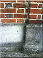
Benchmark on 'The Beaconsfield'
Ordnance Survey cut mark benchmark described on the Bench Mark Database at http://www.bench-marks.org.uk/bm23145. A photo of the building is at Image
Image: © Roger Templeman
Taken: 28 Sep 2010
0.04 miles
10
View across Ock Street to The Beaconsfield and entrance to the Clock House
Image: © Roger Templeman
Taken: 30 Sep 2010
0.04 miles