IMAGES TAKEN NEAR TO
Draymans Walk, ABINGDON, OX14 5GY
Introduction
This page details the photographs taken nearby to Draymans Walk, OX14 5GY by members of the Geograph project.
The Geograph project started in 2005 with the aim of publishing, organising and preserving representative images for every square kilometre of Great Britain, Ireland and the Isle of Man.

There are currently over 7.5m images from over14,400 individuals and you can help contribute to the project by visiting https://www.geograph.org.uk
Image Map (Loading...)


Getting Data...Please wait
Leaflet Map data © OpenStreetMap
Images are licensed for reuse under creativecommons.org/licenses/by-sa/2.0
Notes
- Clicking on the map will re-center to the selected point.
- The higher the marker number, the further away the image location is from the centre of the postcode.
Image Listing (698 Images Found)
Images are licensed for reuse under creativecommons.org/licenses/by-sa/2.0
Image
Details
Distance
1
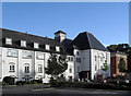
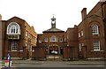
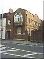
Morlands Brewery - not
OK, people need somewhere to live, but they also need jobs and beer and it's always a shame to see Fat Cat developers trousering the proceeds of shutting down a sizeable local employer just to get their grubby hands on the land.
Morlands Brewery is now a warren of apartment blocks.
Image: © Des Blenkinsopp
Taken: 7 Oct 2010
0.01 miles
2
Morlands Brewery - (not)
Morlands Brewery used to supply beer to most of the pubs in Abingdon, and a large surrounding area.
In the interests of making a few people from somewhere else quite wealthy a lot of local people lost their jobs and odd tasting beer is now brought in by road from miles away.
Image: © Des Blenkinsopp
Taken: 7 Oct 2010
0.03 miles
3
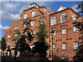
Abingdon - Former Brewery Building
The historic Morland Brewery block is now occupied by modern apartments.
www.abingdon.gov.uk
Image: © Colin Smith
Taken: 26 Aug 2012
0.03 miles
4
Abingdon - Old Brewery Quarter
Modern apartments now occupy the site of the former Morland Brewery.
www.abingdon.gov.uk
Image: © Colin Smith
Taken: 26 Aug 2012
0.04 miles
5
The courtyard and clock tower of Clock House
The Clock House dates from the 1720s. It was built for Benjamin Tomkins and his wife Sarah. The open courtyard with its central clock tower is to the left of the house and was added some 30 years later. It included a stable and a service block, and was designed by Robert Taylor who became a leading architect of his time.
Image: © Steve Daniels
Taken: 10 Apr 2014
0.05 miles
7
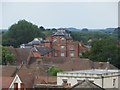
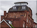
The Brewery
Always a sad day when a brewery closes and when it did, so did a part of Abingdon. Morland is now owned by Greene King (spit).
Image: © Bill Nicholls
Taken: 22 Jun 2014
0.06 miles
8
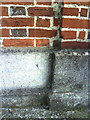
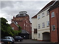
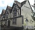
Benchmark on 'The Beaconsfield'
Ordnance Survey cut mark benchmark described on the Bench Mark Database at http://www.bench-marks.org.uk/bm23145. A photo of the building is at Image
Image: © Roger Templeman
Taken: 28 Sep 2010
0.06 miles
9
View across Ock Street to The Beaconsfield and entrance to the Clock House
Image: © Roger Templeman
Taken: 30 Sep 2010
0.06 miles
10
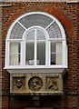
Oriel window in The Clock House
The Mechanics Institute moved into the left wing of the courtyard in 1857. It was succeeded in 1881 by The Beaconsfield Working Men’s Conservative Club. The added oriel window on the Ock Street face of the left wing dates from this time. It is decorated with relief portraits of three late nineteenth century Conservative statesmen including Lord Beaconsfield (Benjamin Disraeli).
Image: © Steve Daniels
Taken: 10 Apr 2014
0.06 miles