IMAGES TAKEN NEAR TO
Bowler Gardens, ABINGDON, OX14 5GE
Introduction
This page details the photographs taken nearby to Bowler Gardens, OX14 5GE by members of the Geograph project.
The Geograph project started in 2005 with the aim of publishing, organising and preserving representative images for every square kilometre of Great Britain, Ireland and the Isle of Man.

There are currently over 7.5m images from over14,400 individuals and you can help contribute to the project by visiting https://www.geograph.org.uk
Image Map (Loading...)


Getting Data...Please wait
Leaflet Map data © OpenStreetMap
Images are licensed for reuse under creativecommons.org/licenses/by-sa/2.0
Notes
- Clicking on the map will re-center to the selected point.
- The higher the marker number, the further away the image location is from the centre of the postcode.
Image Listing (17 Images Found)
Images are licensed for reuse under creativecommons.org/licenses/by-sa/2.0
Image
Details
Distance

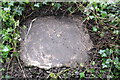
6
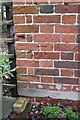
Benchmark on Stonehill Cottage
Ordnance Survey cut mark benchmark described on the Bench Mark Database at http://www.bench-marks.org.uk/bm27131
Image: © Roger Templeman
Taken: 16 Feb 2013
0.14 miles
7
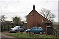
Stonehill Cottage, Stonehill Lane
There is an OS benchmark Image at the left hand side of the front face of the house, above the bonnet of the blue car
Image: © Roger Templeman
Taken: 16 Feb 2013
0.14 miles
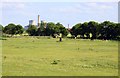
9
Hedge on south side of Masefield Crescent recreation ground
The orange bar on the right hand side of the image is the leg of a children's swing. In the gap in the hedge is a concrete block at ground level which houses an Ordnance Survey triangulation station bolt Image
Image: © Roger Templeman
Taken: 16 Feb 2013
0.19 miles
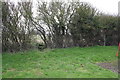
10
Ordnance Survey surface block triangulation station
OS 3rd order trig station comprising brass sphere set in concrete block buried in ditch in hedge in the SW corner of the recreation ground behind Masefield Crescent. See http://www.trigpointinguk.com/trigs/trig-details.php?t=7432 for details
Image: © Roger Templeman
Taken: 16 Feb 2013
0.19 miles