IMAGES TAKEN NEAR TO
Caldecott Road, ABINGDON, OX14 5ET
Introduction
This page details the photographs taken nearby to Caldecott Road, OX14 5ET by members of the Geograph project.
The Geograph project started in 2005 with the aim of publishing, organising and preserving representative images for every square kilometre of Great Britain, Ireland and the Isle of Man.

There are currently over 7.5m images from over14,400 individuals and you can help contribute to the project by visiting https://www.geograph.org.uk
Image Map
Images are licensed for reuse under creativecommons.org/licenses/by-sa/2.0
Notes
- Clicking on the map will re-center to the selected point.
- The higher the marker number, the further away the image location is from the centre of the postcode.
Image Listing (421 Images Found)
Images are licensed for reuse under creativecommons.org/licenses/by-sa/2.0
Image
Details
Distance
2
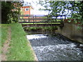
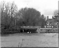
Last bend on the Ock
The River Ock rounds the last bend before flowing into the Thames.
Image: © Bill Nicholls
Taken: 20 Mar 2011
0.10 miles
3
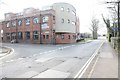
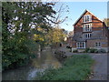
Caldicott Road
View of Caldicott Road and the old laundry on the left.
Image: © Bill Nicholls
Taken: 20 Mar 2011
0.11 miles
5
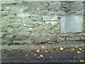
Possible benchmarks on the wall on north side of Caldecott Road
These marks are described on the Bench Mark Database at http://www.bench-marks.org.uk/bm23424
Image: © Roger Templeman
Taken: 4 Oct 2010
0.11 miles
6
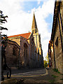
St Helen's Church: Abingdon
A view of the church from the bank of the Thames.
Image: © Pam Brophy
Taken: 8 Oct 2006
0.12 miles
7
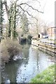
Last bit to the Thames
The last section of the River Ock before it flows into the River Thames.
Image: © Bill Nicholls
Taken: 20 Mar 2011
0.12 miles
8
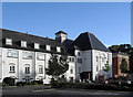
Morlands Brewery - not
OK, people need somewhere to live, but they also need jobs and beer and it's always a shame to see Fat Cat developers trousering the proceeds of shutting down a sizeable local employer just to get their grubby hands on the land.
Morlands Brewery is now a warren of apartment blocks.
Image: © Des Blenkinsopp
Taken: 7 Oct 2010
0.12 miles
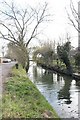
10
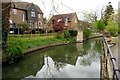
River Thames, confluence with River Ock
Just downstream of here was the junction with the Wilts and Berks Canal, which formerly ran westward for some 52 miles to a junction with the Kennet and Avon Canal at Semington. It has been derelict for many years now and much of the route, especially near Swindon, has been built on. That, however, has not prevented the formation of a society for its restoration. This will be a gargantuan task.
Image: © Dr Neil Clifton
Taken: 7 May 1979
0.12 miles