IMAGES TAKEN NEAR TO
Long Wittenham, ABINGDON, OX14 4QR
Introduction
This page details the photographs taken nearby to OX14 4QR by members of the Geograph project.
The Geograph project started in 2005 with the aim of publishing, organising and preserving representative images for every square kilometre of Great Britain, Ireland and the Isle of Man.

There are currently over 7.5m images from over14,400 individuals and you can help contribute to the project by visiting https://www.geograph.org.uk
Image Map (Loading...)


Getting Data...Please wait
Leaflet Map data © OpenStreetMap
Images are licensed for reuse under creativecommons.org/licenses/by-sa/2.0
Notes
- Clicking on the map will re-center to the selected point.
- The higher the marker number, the further away the image location is from the centre of the postcode.
Image Listing (4 Images Found)
Images are licensed for reuse under creativecommons.org/licenses/by-sa/2.0
Image
Details
Distance
1
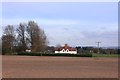
Northfield Farm
Northfield Farm is surrounded by flat, open fields in the centre of a wide meander in the Thames.
The buildings in the distance are in Burcot on the other side of the river.
Image: © Des Blenkinsopp
Taken: 24 Nov 2011
0.04 miles
2
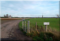
Road to Northfield Farm
Northfield Farm is in the middle of a large patch of flat, open land on the inside of a large Thames meander north of Wittenham Clumps.
Image: © Des Blenkinsopp
Taken: 24 Nov 2011
0.16 miles
4

Looking at Northfield
View towards Northfield farm which can be seen by the trees in the distance.
Image: © Bill Nicholls
Taken: 6 May 2009
0.23 miles