IMAGES TAKEN NEAR TO
Poplar Park, ABINGDON, OX14 4QE
Introduction
This page details the photographs taken nearby to Poplar Park, OX14 4QE by members of the Geograph project.
The Geograph project started in 2005 with the aim of publishing, organising and preserving representative images for every square kilometre of Great Britain, Ireland and the Isle of Man.

There are currently over 7.5m images from over14,400 individuals and you can help contribute to the project by visiting https://www.geograph.org.uk
Image Map
Images are licensed for reuse under creativecommons.org/licenses/by-sa/2.0
Notes
- Clicking on the map will re-center to the selected point.
- The higher the marker number, the further away the image location is from the centre of the postcode.
Image Listing (52 Images Found)
Images are licensed for reuse under creativecommons.org/licenses/by-sa/2.0
Image
Details
Distance
1
Pendon Museum - Long Wittenham
A fantastic museum of models.http://www.pendonmuseum.com/index.jsp
Image: © Colin Babb
Taken: 27 Jun 2010
0.03 miles
2
Sign by the house
I first thought this was a pub but it turns out to be the Pendon Museum http://www.pendonmuseum.com/index.jsp
Image: © Bill Nicholls
Taken: 8 Nov 2009
0.04 miles
3
Pendon Model Railway Museum in Long Wittenham
Image: © Steve Daniels
Taken: 10 May 2009
0.04 miles
4
Park over the field
Mobile home park across the field near the River Thames.
Image: © Bill Nicholls
Taken: 8 Nov 2009
0.04 miles
5
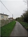
Route 5 past the caravans
Cycle route 5 as it passes the mobile home site at Long Wittenham.
Image: © Bill Nicholls
Taken: 8 Nov 2009
0.04 miles
6
Footpath to Appleford
The footpath eventually leads to Appleford though it's not this good all the way
Image: © Bill Nicholls
Taken: 8 Nov 2009
0.05 miles
7
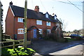
Semi-detached houses at west end of High Street
Both houses have been extended sideways, which in the case of the left hand house, 'Long View', has led to the loss of the Ordnance Survey benchmark on the left hand side of the original house
Image: © Roger Templeman
Taken: 29 Mar 2016
0.05 miles
8
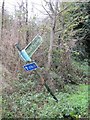
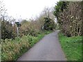
Bent sign by the path
Rather bent sign informing you it's a footpath and cycle route 5 just outside Long Wittenham
Image: © Bill Nicholls
Taken: 8 Nov 2009
0.05 miles
9
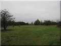
Play area off the path
Looking a bit desolate and unplayed on.
Image: © Bill Nicholls
Taken: 8 Nov 2009
0.06 miles
10
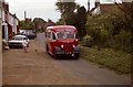
A 1950 Bedford OB Duple in Long Whitenham High Street
Image: © Antony Ewart Smith
Taken: 1 Jun 1986
0.07 miles