IMAGES TAKEN NEAR TO
Appleford, ABINGDON, OX14 4PH
Introduction
This page details the photographs taken nearby to OX14 4PH by members of the Geograph project.
The Geograph project started in 2005 with the aim of publishing, organising and preserving representative images for every square kilometre of Great Britain, Ireland and the Isle of Man.

There are currently over 7.5m images from over14,400 individuals and you can help contribute to the project by visiting https://www.geograph.org.uk
Image Map
Images are licensed for reuse under creativecommons.org/licenses/by-sa/2.0
Notes
- Clicking on the map will re-center to the selected point.
- The higher the marker number, the further away the image location is from the centre of the postcode.
Image Listing (42 Images Found)
Images are licensed for reuse under creativecommons.org/licenses/by-sa/2.0
Image
Details
Distance

7
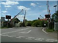
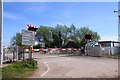
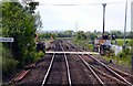
Appleford Crossing
Railway Crossing gates on the main line from Didcot to Oxford. Once only used as a farm crossing, but housing development to the west of the railway line has increased road traffic.
Image: © Colin Bates
Taken: 29 Aug 2005
0.03 miles
8
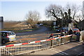
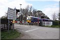
Rail enthusiasts at Appleford level crossing
View from charter train as it exists Appleford sidings
Image: © Roger Templeman
Taken: 14 Jan 2012
0.03 miles

10
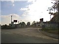
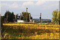
Looking across a field towards Appleford
Image: © Steve Daniels
Taken: 12 Aug 2009
0.04 miles