IMAGES TAKEN NEAR TO
Whitehorns Way, ABINGDON, OX14 4LJ
Introduction
This page details the photographs taken nearby to Whitehorns Way, OX14 4LJ by members of the Geograph project.
The Geograph project started in 2005 with the aim of publishing, organising and preserving representative images for every square kilometre of Great Britain, Ireland and the Isle of Man.

There are currently over 7.5m images from over14,400 individuals and you can help contribute to the project by visiting https://www.geograph.org.uk
Image Map (Loading...)


Getting Data...Please wait
Leaflet Map data © OpenStreetMap
Images are licensed for reuse under creativecommons.org/licenses/by-sa/2.0
Notes
- Clicking on the map will re-center to the selected point.
- The higher the marker number, the further away the image location is from the centre of the postcode.
Image Listing (37 Images Found)
Images are licensed for reuse under creativecommons.org/licenses/by-sa/2.0
Image
Details
Distance
1
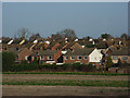
Drayton
Houses in Whitehorns Way on the western edge of the village.
Image: © Andrew Smith
Taken: 3 Dec 2006
0.06 miles
3
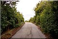
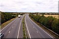
The ramp to the bridge over the A34
The track leads to Manor Farm.
Image: © Steve Daniels
Taken: 8 Aug 2011
0.12 miles
4
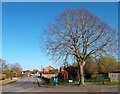
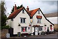
Drayton
In the bottom of the grid square, taken from the bus stop at Drayton Green. Where the B4016 meets the B4017, this is the only proper road junction in Drayton. In the centre of the photo is an old stone cross on a triangular piece of land. The pub just in the photo on the right is the Wheatsheaf.
Image: © Claire Ward
Taken: 5 Jun 2005
0.14 miles
5
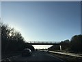
Bridge carrying bridleway across the A34
Image: © Dave Thompson
Taken: 18 Jan 2020
0.14 miles

9
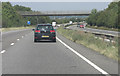
A34 footbridge carrying path from Drayton
Image: © Stuart Logan
Taken: 31 Jul 2011
0.16 miles
10
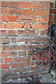
Benchmark on the front of Drayton Baptist Church
The Ordnance Survey cut mark benchmark is described on the Bench Mark Database at http://www.bench-marks.org.uk/bm21431
Image: © Roger Templeman
Taken: 6 Feb 2013
0.16 miles