IMAGES TAKEN NEAR TO
Steventon Road, ABINGDON, OX14 4LE
Introduction
This page details the photographs taken nearby to Steventon Road, OX14 4LE by members of the Geograph project.
The Geograph project started in 2005 with the aim of publishing, organising and preserving representative images for every square kilometre of Great Britain, Ireland and the Isle of Man.

There are currently over 7.5m images from over14,400 individuals and you can help contribute to the project by visiting https://www.geograph.org.uk
Image Map
Images are licensed for reuse under creativecommons.org/licenses/by-sa/2.0
Notes
- Clicking on the map will re-center to the selected point.
- The higher the marker number, the further away the image location is from the centre of the postcode.
Image Listing (32 Images Found)
Images are licensed for reuse under creativecommons.org/licenses/by-sa/2.0
Image
Details
Distance
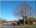
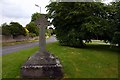
2
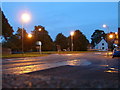
Drayton
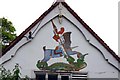
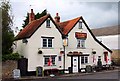
In the bottom of the grid square, taken from the bus stop at Drayton Green. Where the B4016 meets the B4017, this is the only proper road junction in Drayton. In the centre of the photo is an old stone cross on a triangular piece of land. The pub just in the photo on the right is the Wheatsheaf.
Image: © Claire Ward
Taken: 5 Jun 2005
0.09 miles