IMAGES TAKEN NEAR TO
Steventon Road, ABINGDON, OX14 4LA
Introduction
This page details the photographs taken nearby to Steventon Road, OX14 4LA by members of the Geograph project.
The Geograph project started in 2005 with the aim of publishing, organising and preserving representative images for every square kilometre of Great Britain, Ireland and the Isle of Man.

There are currently over 7.5m images from over14,400 individuals and you can help contribute to the project by visiting https://www.geograph.org.uk
Image Map (15 Images)


Getting Data...Please wait
Leaflet Map data © OpenStreetMap
Images are licensed for reuse under creativecommons.org/licenses/by-sa/2.0
Notes
- Clicking on the map will re-center to the selected point.
- The higher the marker number, the further away the image location is from the centre of the postcode.
Image Listing (15 Images Found)
Images are licensed for reuse under creativecommons.org/licenses/by-sa/2.0
Image
Details
Distance
1
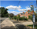
Haywards Road Bus Stop
This is Steventon Road. Haywards Road is off to the right.
Image: © Des Blenkinsopp
Taken: 29 Jul 2014
0.06 miles
2
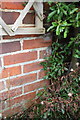
Benchmark on #97 Steventon Road
Ordnance Survey cut mark benchmark described on the Bench Mark Database at http://www.bench-marks.org.uk/bm27110
Image: © Roger Templeman
Taken: 24 Jan 2013
0.08 miles
3
#97 Steventon Road
The house is at the end of a row of 4 houses and has an OS benchmark Image on the near corner left of the water butt and behind a shrub.
Image: © Roger Templeman
Taken: 24 Jan 2013
0.08 miles
4
Ping outside the Recycling Site
Better than Pong. Must be a well run site.
Image: © Des Blenkinsopp
Taken: 29 Jul 2014
0.12 miles
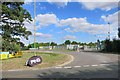
5
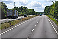
Vale of White Horse : The A34
The road passes through the Vale of White Horse district.
Image: © Lewis Clarke
Taken: 29 Jun 2014
0.14 miles
6
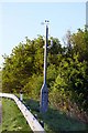
Weather monitor on the A34 near Drayton
Image: © Steve Daniels
Taken: 2 May 2009
0.15 miles
7
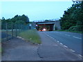
The A34 crossing the old A34 now the B4017
The fenced off area to the left was at one time a slip road onto the A34 when the dual-carriage way was under construction in the 1970s.
Image: © Claire Ward
Taken: 6 Jun 2005
0.18 miles
8
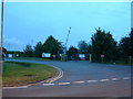
Drayton Waste Recycling Centre
In the central lower half of the grid square and just north of the A34. The road to the left leads to Drayton Golf Club.
Image: © Claire Ward
Taken: 5 Jun 2005
0.18 miles

